IMAGES TAKEN NEAR TO
Plantation Street, ROSSENDALE, BB4 7NZ
Introduction
This page details the photographs taken nearby to Plantation Street, BB4 7NZ by members of the Geograph project.
The Geograph project started in 2005 with the aim of publishing, organising and preserving representative images for every square kilometre of Great Britain, Ireland and the Isle of Man.

There are currently over 7.5m images from over14,400 individuals and you can help contribute to the project by visiting https://www.geograph.org.uk
Image Map
Images are licensed for reuse under creativecommons.org/licenses/by-sa/2.0
Notes
- Clicking on the map will re-center to the selected point.
- The higher the marker number, the further away the image location is from the centre of the postcode.
Image Listing (135 Images Found)
Images are licensed for reuse under creativecommons.org/licenses/by-sa/2.0
Image
Details
Distance
4
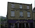
Ashoka Rawtenstall
Was the Co-Op on Bacup Road. Note the inscription "Cawl Terrace Industrial Society, 1860" - a local co-operative group which merged with the main Co-op.
Image: © Robert Wade
Taken: 10 Jun 2007
0.08 miles
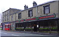
6
New Staff Car Park for the Health Hub
The "old" Health Centre has been demolished and is now a staff car park for the new health hub on the opposite side of Bacup Road a new pedestrian crossing has now been installed to prevent them getting run over
Image: © Robert Wade
Taken: 29 Jun 2010
0.09 miles
7
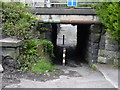
Subway Under Bocholt Way.
This subway was built under the Rawtenstall to Bacup railway line. Following its closure Bocholt Way A681 now passes overhead.
Image: © Robert Wade
Taken: 24 Jul 2007
0.09 miles
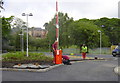
9
New Pedestrian Crossing, Bacup Road
Connecting the old and new Health Centre sites
Image: © Robert Wade
Taken: 29 Jun 2010
0.11 miles