IMAGES TAKEN NEAR TO
Lench Road, ROSSENDALE, BB4 7JH
Introduction
This page details the photographs taken nearby to Lench Road, BB4 7JH by members of the Geograph project.
The Geograph project started in 2005 with the aim of publishing, organising and preserving representative images for every square kilometre of Great Britain, Ireland and the Isle of Man.

There are currently over 7.5m images from over14,400 individuals and you can help contribute to the project by visiting https://www.geograph.org.uk
Image Map (Loading...)


Getting Data...Please wait
Leaflet Map data © OpenStreetMap
Images are licensed for reuse under creativecommons.org/licenses/by-sa/2.0
Notes
- Clicking on the map will re-center to the selected point.
- The higher the marker number, the further away the image location is from the centre of the postcode.
Image Listing (41 Images Found)
Images are licensed for reuse under creativecommons.org/licenses/by-sa/2.0
Image
Details
Distance
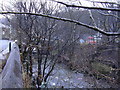
2
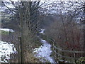
Footpath to Rawtenstall
This roughly follows the route of the disused railway.
Image: © Robert Wade
Taken: 12 Dec 2008
0.08 miles
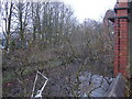
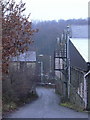
7
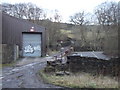
Lane at Hareholme
The railway used to run across this scene just behind the industrial unit
Image: © Robert Wade
Taken: 5 Jan 2011
0.12 miles