IMAGES TAKEN NEAR TO
Hardman Drive, ROSSENDALE, BB4 7DD
Introduction
This page details the photographs taken nearby to Hardman Drive, BB4 7DD by members of the Geograph project.
The Geograph project started in 2005 with the aim of publishing, organising and preserving representative images for every square kilometre of Great Britain, Ireland and the Isle of Man.

There are currently over 7.5m images from over14,400 individuals and you can help contribute to the project by visiting https://www.geograph.org.uk
Image Map
Images are licensed for reuse under creativecommons.org/licenses/by-sa/2.0
Notes
- Clicking on the map will re-center to the selected point.
- The higher the marker number, the further away the image location is from the centre of the postcode.
Image Listing (58 Images Found)
Images are licensed for reuse under creativecommons.org/licenses/by-sa/2.0
Image
Details
Distance


5
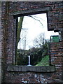
"Now through the Square window children"
Looking through old mill window at waterfall on Cowpe Brook
Image: © Alexander P Kapp
Taken: 6 Feb 2008
0.11 miles
7
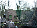
Ruin
Of probably a water powered industrial building.
Image: © Alexander P Kapp
Taken: 6 Feb 2008
0.12 miles
8
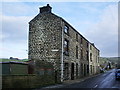
Hodgson's Buildings, Cowpe
Tall and narrow they have been squeezed in between the road and the stream which flows behind the terrace
Image: © Alexander P Kapp
Taken: 6 Feb 2008
0.12 miles
9
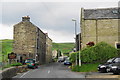
The road through Cowpe
Most of Cowpe is a long ribbon lining the road which goes up the valley. The building on the left, Hodgson's Buildings, really does lean in a bit - it isn't just my lens.
Image: © Bill Boaden
Taken: 10 Jun 2012
0.13 miles
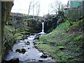
10
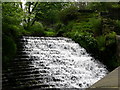
Weir near Hugh Mill, Waterfoot, Lancashire: 2007
See picture from 1949 Image
Image: © liz dawson
Taken: 19 May 2007
0.14 miles