IMAGES TAKEN NEAR TO
Ivy Street, ROSSENDALE, BB4 7AX
Introduction
This page details the photographs taken nearby to Ivy Street, BB4 7AX by members of the Geograph project.
The Geograph project started in 2005 with the aim of publishing, organising and preserving representative images for every square kilometre of Great Britain, Ireland and the Isle of Man.

There are currently over 7.5m images from over14,400 individuals and you can help contribute to the project by visiting https://www.geograph.org.uk
Image Map
Images are licensed for reuse under creativecommons.org/licenses/by-sa/2.0
Notes
- Clicking on the map will re-center to the selected point.
- The higher the marker number, the further away the image location is from the centre of the postcode.
Image Listing (153 Images Found)
Images are licensed for reuse under creativecommons.org/licenses/by-sa/2.0
Image
Details
Distance
1
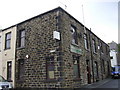
Waterfoot Social Club
This used to be Waterfoot Working Men's Club
Image: © Robert Wade
Taken: 21 May 2009
0.01 miles
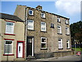
2
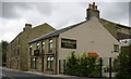
"Glen Valley Guest House" 634 Bacup Road, Waterfoot, Rossendale, BB4 7AW
Used to be the Moulders Arms.
Image: © Robert Wade
Taken: 24 Jul 2007
0.03 miles
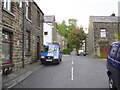
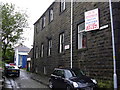
8
Downtown Waterfoot
Cowpe Road forming a junction onto the Bacup Road, A681 in the Rossendale Valley
Image: © Chris Heaton
Taken: 21 Oct 2024
0.07 miles
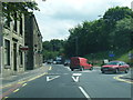
9
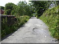
The Pennine Bridleway Mary Towneley loop near Hugh Mill
Image: © Dave Kelly
Taken: 4 Jul 2019
0.07 miles
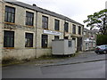
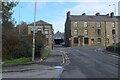
10
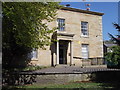
Bridge End House, Waterfoot (Was Waterfoot Library)
Image: © Robert Wade
Taken: 28 Apr 2011
0.07 miles