IMAGES TAKEN NEAR TO
Yarmouth Avenue, ROSSENDALE, BB4 6SU
Introduction
This page details the photographs taken nearby to Yarmouth Avenue, BB4 6SU by members of the Geograph project.
The Geograph project started in 2005 with the aim of publishing, organising and preserving representative images for every square kilometre of Great Britain, Ireland and the Isle of Man.

There are currently over 7.5m images from over14,400 individuals and you can help contribute to the project by visiting https://www.geograph.org.uk
Image Map
Images are licensed for reuse under creativecommons.org/licenses/by-sa/2.0
Notes
- Clicking on the map will re-center to the selected point.
- The higher the marker number, the further away the image location is from the centre of the postcode.
Image Listing (42 Images Found)
Images are licensed for reuse under creativecommons.org/licenses/by-sa/2.0
Image
Details
Distance
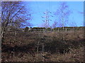
2
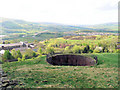
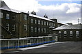
Disused Reservoir or Water Tank
This large disused water tank is situated on the hillside behind Rossendale Hospital, a Victorian building. The tank seems to date from a similar period.
Image: © Peter Worrell
Taken: 26 Apr 2009
0.05 miles

10
Emergency Power Line Work following the Gas Explosion at Townsendfold
Image: © Robert Wade
Taken: 26 Dec 2008
0.15 miles