IMAGES TAKEN NEAR TO
Rawtenstall Road End, ROSSENDALE, BB4 6QE
Introduction
This page details the photographs taken nearby to Rawtenstall Road End, BB4 6QE by members of the Geograph project.
The Geograph project started in 2005 with the aim of publishing, organising and preserving representative images for every square kilometre of Great Britain, Ireland and the Isle of Man.

There are currently over 7.5m images from over14,400 individuals and you can help contribute to the project by visiting https://www.geograph.org.uk
Image Map (Loading...)


Getting Data...Please wait
Leaflet Map data © OpenStreetMap
Images are licensed for reuse under creativecommons.org/licenses/by-sa/2.0
Notes
- Clicking on the map will re-center to the selected point.
- The higher the marker number, the further away the image location is from the centre of the postcode.
Image Listing (101 Images Found)
Images are licensed for reuse under creativecommons.org/licenses/by-sa/2.0
Image
Details
Distance
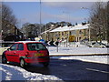
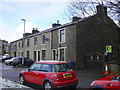
1
Rawtenstall Road, Haslingden, Lancashire
Image: © Robert Wade
Taken: 16 Feb 2010
0.01 miles
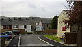
2
Rawtenstall Road, Haslingden, Lancashire
Image: © Robert Wade
Taken: 16 Feb 2010
0.01 miles
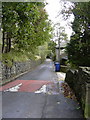
4
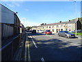
Manchester Road (A680), Haslingden
Looking north west.
Image: © JThomas
Taken: 25 Sep 2018
0.02 miles
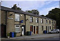
5
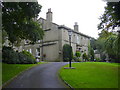
Houses on Manchester Road (A680), Haslingden
Image: © JThomas
Taken: 25 Sep 2018
0.02 miles
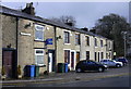
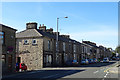
7
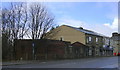
Manchester Road, Haslingden
I think the red brick building used to public lavatories
Image: © Robert Wade
Taken: 16 Feb 2010
0.03 miles