IMAGES TAKEN NEAR TO
Bentgate Close, ROSSENDALE, BB4 6LT
Introduction
This page details the photographs taken nearby to Bentgate Close, BB4 6LT by members of the Geograph project.
The Geograph project started in 2005 with the aim of publishing, organising and preserving representative images for every square kilometre of Great Britain, Ireland and the Isle of Man.

There are currently over 7.5m images from over14,400 individuals and you can help contribute to the project by visiting https://www.geograph.org.uk
Image Map
Images are licensed for reuse under creativecommons.org/licenses/by-sa/2.0
Notes
- Clicking on the map will re-center to the selected point.
- The higher the marker number, the further away the image location is from the centre of the postcode.
Image Listing (67 Images Found)
Images are licensed for reuse under creativecommons.org/licenses/by-sa/2.0
Image
Details
Distance
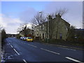
2
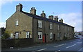
"Rainbow Childcare" Manchester Road, Bent Gate, Haslingden, Rossendale, BB4 6LN
Image: © Robert Wade
Taken: 16 Feb 2010
0.03 miles

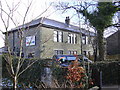
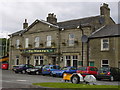
4
Tor View School, Clod Lane
Used as a Command Centre following the gas explosion at Townsendfold on 221209.
Image: © Robert Wade
Taken: 24 Dec 2008
0.05 miles

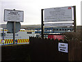
6
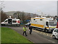
National Grid Mobile Command Unit
Following an explosion at major gas main in December 2008 at nearby in Townsend Fold http://www.geograph.org.uk/photo/1088309 an emergency command centre was set up at Tor View School above.
With the incident happening two days before Christmas around 300 engineers worked "around-the-clock" to restore services.http://news.bbc.co.uk/1/hi/england/lancashire/7796832.stm
Work to repair the damaged gas pipe was completed on Tuesday 23rd of December, but engineers had to re-pressurise and test the system, as well as checking each of the 18,000 individual properties.
Director of operations Jon Butterworth said "This was a mammoth task but local people were fantastic I want to apologise for the inconvenience but also to thank people for their patience while we have been fixing the problem, and also for letting us into their homes during the night to get their gas supplies on for Christmas".
The blast on Monday morning the 22nd of December left 18,000 homes without gas and 17,000 without electricity in the Bacup, Waterfoot, Rawtenstall, Newchurch and Crawshawbooth areas.
Image
Image: © Paul Anderson
Taken: 24 Dec 2008
0.06 miles
8
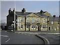
"The Woolpack" (Pub) 488 Manchester Road, Haslingden, Rossendale, Lancashire, BB4 6LN
Image: © Robert Wade
Taken: 16 Feb 2010
0.07 miles
10
The Woolpack
used to have an all day licence when the cattle market was open but it has now been demolished
Image: © Robert Wade
Taken: 10 Jul 2007
0.07 miles