IMAGES TAKEN NEAR TO
Duckworth Lane, ROSSENDALE, BB4 6JL
Introduction
This page details the photographs taken nearby to Duckworth Lane, BB4 6JL by members of the Geograph project.
The Geograph project started in 2005 with the aim of publishing, organising and preserving representative images for every square kilometre of Great Britain, Ireland and the Isle of Man.

There are currently over 7.5m images from over14,400 individuals and you can help contribute to the project by visiting https://www.geograph.org.uk
Image Map
Images are licensed for reuse under creativecommons.org/licenses/by-sa/2.0
Notes
- Clicking on the map will re-center to the selected point.
- The higher the marker number, the further away the image location is from the centre of the postcode.
Image Listing (107 Images Found)
Images are licensed for reuse under creativecommons.org/licenses/by-sa/2.0
Image
Details
Distance
4
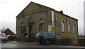
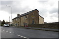
Converted Chapel, Bury Road, Townsendfold
Image: © Robert Wade
Taken: 14 Nov 2008
0.04 miles
7
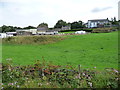
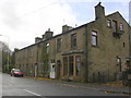
Properties on Bury Road, Townsend Fold
On the eastern slopes of the Irwell valley.
Image: © Christine Johnstone
Taken: 6 Sep 2018
0.08 miles
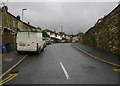
9
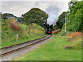
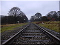
East Lancashire Railway near Townsend Fold
Image: © David Dixon
Taken: 13 Oct 2016
0.09 miles
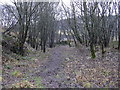
10
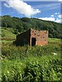
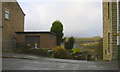
Derelict trackside building
Near Townsend Fold as viewed from an East Lancashire Railway train bound for Heywood.
Image: © Richard Hoare
Taken: 2 Jul 2017
0.10 miles