1
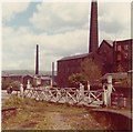
Disused level crossing and Bacup line trackbed
The view from the platform end at Rawtenstall station on the final day of British Rail operation, June 3rd 1972. The trackbed which had led to Bacup is now a road and most of the buildings, particularly the former cotton mills, have gone too.
Image: © Peter Whatley
Taken: 3 Jun 1972
0.01 miles
2
Footbridge Over the River Irwell
This leads to the Tesco superstore to the right of this photo.
Image: © Robert Wade
Taken: 10 Feb 2008
0.02 miles
3
Rawtenstall Station
Image: © David Dixon
Taken: 15 Apr 2010
0.02 miles
4
Tesco on Christmas Day 2006
Tesco Rawtenstall on Christmas Day rows of shopping trolleys having their only day off of the year and not a single car in sight.
Image: © Paul Anderson
Taken: 25 Dec 2006
0.02 miles
5
Rawtenstall Station
Northern terminus of the East Lancashire Railway: http://www.eastlancsrailway.org.uk/
Image: © Mike Faherty
Taken: 23 Jan 2017
0.02 miles
6
Rawtenstall Station
Despite its authentic appearance, this building dates only from 1992, although it is in the style of an East Lancashire Railway station. Until 1966 Rawtenstall was a through station, the line continuing east to Bacup and this building has been sited where the track used to be.
Image: © Stephen McKay
Taken: 3 May 2017
0.02 miles
7
Rawtenstall Station
Despite its authentic appearance, this building dates only from 1992, although it is in the style of an East Lancashire Railway station. Until 1966 Rawtenstall was a through station, the line continuing east to Bacup and this building has been sited where the track used to be. In the latter days of the British Rail passenger service - withdrawn in 1972 - there was only a bus shelter here.
Image: © Stephen McKay
Taken: 3 May 2017
0.02 miles
8
Rawtenstall station building
On the East Lancashire heritage railway. The station was opened in 1846 and closed to passengers in 1972. After closure, the building was demolished and has been rebuilt by the Heritage line, but not in its original footprint.
Image: © John Lucas
Taken: 27 Oct 2022
0.02 miles
9
Small weir on River Irwell
Viewed from the footbridge.
Image: © Richard Hoare
Taken: 2 Jul 2017
0.02 miles
10
Rawtenstall station buildings
The northern terminus of the ELR.
Image: © Stephen Craven
Taken: 26 Aug 2012
0.02 miles


