IMAGES TAKEN NEAR TO
Manchester Road, ROSSENDALE, BB4 5ST
Introduction
This page details the photographs taken nearby to Manchester Road, BB4 5ST by members of the Geograph project.
The Geograph project started in 2005 with the aim of publishing, organising and preserving representative images for every square kilometre of Great Britain, Ireland and the Isle of Man.

There are currently over 7.5m images from over14,400 individuals and you can help contribute to the project by visiting https://www.geograph.org.uk
Image Map
Images are licensed for reuse under creativecommons.org/licenses/by-sa/2.0
Notes
- Clicking on the map will re-center to the selected point.
- The higher the marker number, the further away the image location is from the centre of the postcode.
Image Listing (396 Images Found)
Images are licensed for reuse under creativecommons.org/licenses/by-sa/2.0
Image
Details
Distance
2
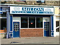
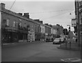
Indian Takeaway in Manchester Road
This takeaway was originally a greengrocer's shop.
Image: © Roy Haworth
Taken: 19 Mar 2005
0.02 miles
3
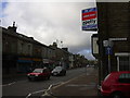
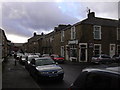
Manchester Road
The "Indian" has been destroyed by fire.
Image: © Robert Wade
Taken: 15 Dec 2008
0.02 miles
4
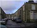
Masjid-e-Bilal & Islamic Centre, 2-4 Beaconsfield Street
Image: © Robert Wade
Taken: 23 Jan 2009
0.03 miles
5
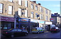
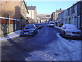
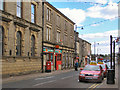
Manchester Road
For this scene eighty years ago please go to http://www.flickr.com/photos/rossendalewadey/3278392631/
Image: © Robert Wade
Taken: 18 Feb 2009
0.03 miles
9
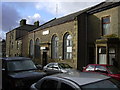
Haslingden Post Office
The Post Office on Deardengate.
Image: © David Dixon
Taken: 19 Jun 2010
0.04 miles
10
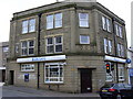
"Barclays Bank" Upper Deardengate, Haslingden, Rossendale, Lancashire BB4 5QJ
Was Martins Bank, corner of Pleasant Street and Upper Deardengate
Image: © Robert Wade
Taken: 10 Jun 2007
0.04 miles