IMAGES TAKEN NEAR TO
High Street, ROSSENDALE, BB4 5RB
Introduction
This page details the photographs taken nearby to High Street, BB4 5RB by members of the Geograph project.
The Geograph project started in 2005 with the aim of publishing, organising and preserving representative images for every square kilometre of Great Britain, Ireland and the Isle of Man.

There are currently over 7.5m images from over14,400 individuals and you can help contribute to the project by visiting https://www.geograph.org.uk
Image Map
Images are licensed for reuse under creativecommons.org/licenses/by-sa/2.0
Notes
- Clicking on the map will re-center to the selected point.
- The higher the marker number, the further away the image location is from the centre of the postcode.
Image Listing (250 Images Found)
Images are licensed for reuse under creativecommons.org/licenses/by-sa/2.0
Image
Details
Distance
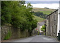
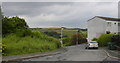
3
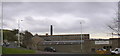
Rakefoot
With Hargreaves Street Mill in the background.
Image: © Robert Wade
Taken: 3 Mar 2009
0.04 miles
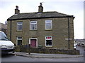
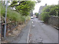
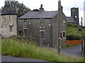
6
Rake House was "The Unity Club"
used to be a WM Club
Image: © Robert Wade
Taken: 21 Jun 2007
0.07 miles
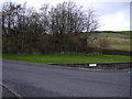
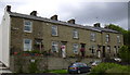
8
Spring Lane
from the site of the demolished Spring Lane WM Club. St James in background
Image: © Robert Wade
Taken: 10 Jul 2007
0.08 miles