IMAGES TAKEN NEAR TO
Cedar Avenue, ROSSENDALE, BB4 5NH
Introduction
This page details the photographs taken nearby to Cedar Avenue, BB4 5NH by members of the Geograph project.
The Geograph project started in 2005 with the aim of publishing, organising and preserving representative images for every square kilometre of Great Britain, Ireland and the Isle of Man.

There are currently over 7.5m images from over14,400 individuals and you can help contribute to the project by visiting https://www.geograph.org.uk
Image Map
Images are licensed for reuse under creativecommons.org/licenses/by-sa/2.0
Notes
- Clicking on the map will re-center to the selected point.
- The higher the marker number, the further away the image location is from the centre of the postcode.
Image Listing (145 Images Found)
Images are licensed for reuse under creativecommons.org/licenses/by-sa/2.0
Image
Details
Distance
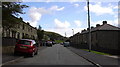
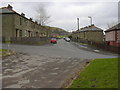
4
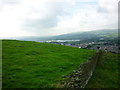
Haslingden
Looking down towards the town, from Cribden End Lane.
Image: © David Dixon
Taken: 28 Feb 2013
0.03 miles
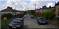
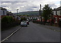
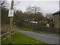
5
Cedar Avenue, Haslingden
Part of the Hillside estate
Image: © Robert Wade
Taken: 21 Mar 2011
0.03 miles
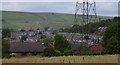
6
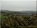
Cribden End Lane to Stubbins
Taken on Cribden End Lane, Top O'Slate, Haslingden, Lancashire, I am looking south across Longshoot to Stubbins on the southern edge of Rossendale. The SCA paper mill can be identified by its plume of smoke in the distance. The conurbation of Greater Manchester spreads along the far horizon beyond.
Image: © Carroll Pierce
Taken: 13 Mar 2017
0.03 miles
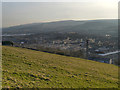
7
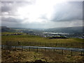
From Top O'Slate to Manchester
Taken from Top O'Slate, Haslingden, and looking towards Manchester, with Harcles Hill and Holcombe to the right, Edenfield to the left and Haslingden in the middle distance.
Image: © Carroll Pierce
Taken: 19 Apr 2013
0.06 miles
9
To Helmshore and Harcles
Featuring four Lancashire aitches, I am on Cribden End Lane coming down from Top O'Slate and looking across Haslingden and Helmshore to Harcles and Holcombe.
Image: © Carroll Pierce
Taken: 24 Aug 2012
0.07 miles
10
Pigeon Lofts-Hen Pens top of Poplar Street
Image: © Robert Wade
Taken: 21 Mar 2011
0.08 miles