IMAGES TAKEN NEAR TO
Grane Road, ROSSENDALE, BB4 5ER
Introduction
This page details the photographs taken nearby to Grane Road, BB4 5ER by members of the Geograph project.
The Geograph project started in 2005 with the aim of publishing, organising and preserving representative images for every square kilometre of Great Britain, Ireland and the Isle of Man.

There are currently over 7.5m images from over14,400 individuals and you can help contribute to the project by visiting https://www.geograph.org.uk
Image Map
Images are licensed for reuse under creativecommons.org/licenses/by-sa/2.0
Notes
- Clicking on the map will re-center to the selected point.
- The higher the marker number, the further away the image location is from the centre of the postcode.
Image Listing (115 Images Found)
Images are licensed for reuse under creativecommons.org/licenses/by-sa/2.0
Image
Details
Distance
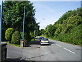
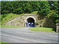
1
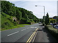
Grane Road
The bridge is carrying the A56 Haslingden by-pass. The green pole in the foreground is for helicopter surveys of gas mains.
Image: © Robert Wade
Taken: 20 Jul 2007
0.03 miles
4
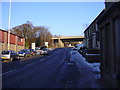
Grane Road, Haslingden
With the A56 bypass flyover in the distance.
Image: © Robert Wade
Taken: 6 Jan 2009
0.03 miles
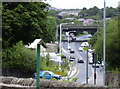
5
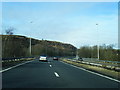
A56 northbound crosses the B6232 Grane Road
Image: © Colin Pyle
Taken: 16 Feb 2013
0.04 miles
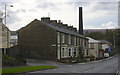
7
Railway bridge
Now used as a means of access on to St Crispin Way, from works on the other side of the dismantled railway
Image: © Alexander P Kapp
Taken: 21 Jul 2008
0.04 miles
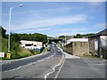
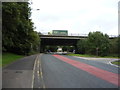
8
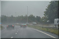
Haslingden : The A56
Looking along the A56.
Image: © Lewis Clarke
Taken: 27 Sep 2019
0.04 miles