IMAGES TAKEN NEAR TO
West View, ROSSENDALE, BB4 5DA
Introduction
This page details the photographs taken nearby to West View, BB4 5DA by members of the Geograph project.
The Geograph project started in 2005 with the aim of publishing, organising and preserving representative images for every square kilometre of Great Britain, Ireland and the Isle of Man.

There are currently over 7.5m images from over14,400 individuals and you can help contribute to the project by visiting https://www.geograph.org.uk
Image Map
Images are licensed for reuse under creativecommons.org/licenses/by-sa/2.0
Notes
- Clicking on the map will re-center to the selected point.
- The higher the marker number, the further away the image location is from the centre of the postcode.
Image Listing (182 Images Found)
Images are licensed for reuse under creativecommons.org/licenses/by-sa/2.0
Image
Details
Distance
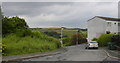
1
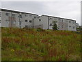
West View Haslingden
built on the site of several rows of terraced houses by a Manchester housing association in the 1970s
Image: © Robert Wade
Taken: 10 Jul 2007
0.03 miles
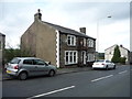
2
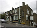
Griffin Inn Hud Rake
Has its own micro brewery
Image: © Robert Wade
Taken: 10 Jul 2007
0.03 miles
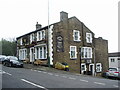
6
The Griffin public house, Haslingden
On Hud Rake.
Image: © JThomas
Taken: 17 Sep 2018
0.05 miles
7
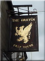
Sign for the Griffin public house, Haslingden
Image: © JThomas
Taken: 17 Sep 2018
0.06 miles
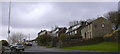
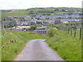
10
Spring Lane
from the site of the demolished Spring Lane WM Club. St James in background
Image: © Robert Wade
Taken: 10 Jul 2007
0.08 miles