IMAGES TAKEN NEAR TO
Grane Road, ROSSENDALE, BB4 4PD
Introduction
This page details the photographs taken nearby to Grane Road, BB4 4PD by members of the Geograph project.
The Geograph project started in 2005 with the aim of publishing, organising and preserving representative images for every square kilometre of Great Britain, Ireland and the Isle of Man.

There are currently over 7.5m images from over14,400 individuals and you can help contribute to the project by visiting https://www.geograph.org.uk
Image Map
Images are licensed for reuse under creativecommons.org/licenses/by-sa/2.0
Notes
- Clicking on the map will re-center to the selected point.
- The higher the marker number, the further away the image location is from the centre of the postcode.
Image Listing (111 Images Found)
Images are licensed for reuse under creativecommons.org/licenses/by-sa/2.0
Image
Details
Distance
2

Footpath leading up to Hutch Bank Quarry
Image: © Chris Heaton
Taken: 28 Aug 2021
0.05 miles
6
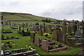
Haslingden Cemetery
The setting is enhanced by the open hillside behind.
Image: © Bill Boaden
Taken: 2 May 2010
0.07 miles
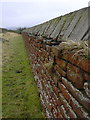
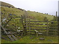
7
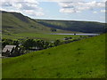
Dry Stone Walls
and sheep shelter perhaps ?
Image: © Robert Wade
Taken: 3 Jun 2011
0.07 miles
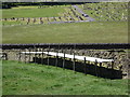
8
Haslingden Cemetery Chapel, Grane Haslingden
Holden Wood Reservoir can be seen in the background.
Image: © Robert Wade
Taken: 30 May 2005
0.07 miles