IMAGES TAKEN NEAR TO
Marsh House Lane, DARWEN, BB3 3SB
Introduction
This page details the photographs taken nearby to Marsh House Lane, BB3 3SB by members of the Geograph project.
The Geograph project started in 2005 with the aim of publishing, organising and preserving representative images for every square kilometre of Great Britain, Ireland and the Isle of Man.

There are currently over 7.5m images from over14,400 individuals and you can help contribute to the project by visiting https://www.geograph.org.uk
Image Map (Loading...)


Getting Data...Please wait
Leaflet Map data © OpenStreetMap
Images are licensed for reuse under creativecommons.org/licenses/by-sa/2.0
Notes
- Clicking on the map will re-center to the selected point.
- The higher the marker number, the further away the image location is from the centre of the postcode.
Image Listing (4 Images Found)
Images are licensed for reuse under creativecommons.org/licenses/by-sa/2.0
Image
Details
Distance
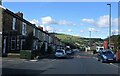
2
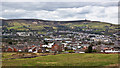
The view over Darwen from the bridleway at Marsh House
Image: © Ian Greig
Taken: 27 Mar 2015
0.20 miles
3
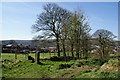
The top of the lane into Darwen
This is now a green track, but the gateposts suggest it predates the surrounding housing.
Image: © Bill Boaden
Taken: 9 Apr 2011
0.21 miles
4
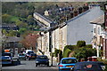
Ellison Fold Terrace, Darwen
On the opposite side of the valley you can see the terrace on Punstock Road.
Image: © Bill Boaden
Taken: 9 Apr 2011
0.24 miles