IMAGES TAKEN NEAR TO
Stock Clough, DARWEN, BB3 3QB
Introduction
This page details the photographs taken nearby to Stock Clough, BB3 3QB by members of the Geograph project.
The Geograph project started in 2005 with the aim of publishing, organising and preserving representative images for every square kilometre of Great Britain, Ireland and the Isle of Man.

There are currently over 7.5m images from over14,400 individuals and you can help contribute to the project by visiting https://www.geograph.org.uk
Image Map
Images are licensed for reuse under creativecommons.org/licenses/by-sa/2.0
Notes
- Clicking on the map will re-center to the selected point.
- The higher the marker number, the further away the image location is from the centre of the postcode.
Image Listing (18 Images Found)
Images are licensed for reuse under creativecommons.org/licenses/by-sa/2.0
Image
Details
Distance
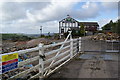
1
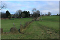
Footpath heading for Lower Scholes Farm
Passes an unusual mode of enclosure, utilising vertical stones - similar to field features found in the Wycoller area to the east of here.
Image: © Chris Heaton
Taken: 15 Jan 2022
0.10 miles
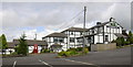
3
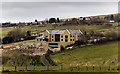
Old Rosins Inn
New building on the site of Old Rosins Inn.
Image: © Peter McDermott
Taken: 19 Mar 2016
0.15 miles
4
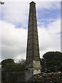
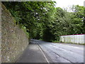
Chimney (St.Paul's Mill) the former Vernon-Carus mill in Johnson New Road Hoddlesden
The mill burnt down a few months ago, it was to be converted to sheltered accommodation.
Image: © Robert Wade
Taken: 23 Jul 2009
0.15 miles
5
Old Rosins Inn, Pickup Bank
Now a closed demolition site. I'm not sure whether the remaining part of the building will be refurbished or demolished.
Image: © Bill Boaden
Taken: 29 Sep 2012
0.17 miles
7
Old Rosins Inn Treacle Row Pickup Bank Hoddlesden Lancashire BB3 3QD
Image: © Robert Wade
Taken: 23 Jul 2009
0.18 miles
9
Johnson New Road, Hoddlesden
The hoardings on the right are protecting the burnt down mill site
Image: © Robert Wade
Taken: 23 Jul 2009
0.20 miles
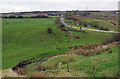
10
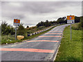
Pickup Bank, Long Hey Lane
Rumble strips on the road surface give an audible addition to the visual warning that the speed limit changes here from the national speed limit (60mph) to a "built up area limit" (30mph). If that isn't sufficient, there's even pictures of speed cameras to slow you down.
Image: © David Dixon
Taken: 20 Jul 2011
0.20 miles