IMAGES TAKEN NEAR TO
Pole Lane, DARWEN, BB3 3LD
Introduction
This page details the photographs taken nearby to Pole Lane, BB3 3LD by members of the Geograph project.
The Geograph project started in 2005 with the aim of publishing, organising and preserving representative images for every square kilometre of Great Britain, Ireland and the Isle of Man.

There are currently over 7.5m images from over14,400 individuals and you can help contribute to the project by visiting https://www.geograph.org.uk
Image Map
Images are licensed for reuse under creativecommons.org/licenses/by-sa/2.0
Notes
- Clicking on the map will re-center to the selected point.
- The higher the marker number, the further away the image location is from the centre of the postcode.
Image Listing (9 Images Found)
Images are licensed for reuse under creativecommons.org/licenses/by-sa/2.0
Image
Details
Distance
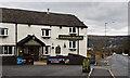
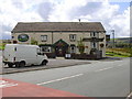
4

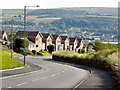
Craven Heifer, Darwen
Located on Pole Lane in Darwen.
Unusual name for a hostelry outside the Craven area, centred around Skipton in Yorkshire. It refers to a heifer that weighed over a ton and was bred in Gargrave, 1807.
Image: © Chris Heaton
Taken: 15 Jan 2022
0.11 miles
6
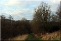
Entering Woodland Area from Priory Drive, Darwen
Small area of woodland in Darwen, bounded by Priory Drive, Pole Lane and Sough Lane
Image: © Chris Heaton
Taken: 15 Jan 2022
0.17 miles
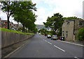
7
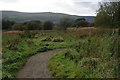
Pole Lane
Dropping down the hill towards Darwen
Image: © David Dixon
Taken: 14 Jul 2011
0.19 miles

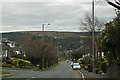
9
Path from Blacksnape to Darwen
Darwen is in the valley bottom ahead.
Image: © Bill Boaden
Taken: 29 Sep 2012
0.24 miles