IMAGES TAKEN NEAR TO
Sudellside Street, DARWEN, BB3 3JD
Introduction
This page details the photographs taken nearby to Sudellside Street, BB3 3JD by members of the Geograph project.
The Geograph project started in 2005 with the aim of publishing, organising and preserving representative images for every square kilometre of Great Britain, Ireland and the Isle of Man.

There are currently over 7.5m images from over14,400 individuals and you can help contribute to the project by visiting https://www.geograph.org.uk
Image Map
Images are licensed for reuse under creativecommons.org/licenses/by-sa/2.0
Notes
- Clicking on the map will re-center to the selected point.
- The higher the marker number, the further away the image location is from the centre of the postcode.
Image Listing (14 Images Found)
Images are licensed for reuse under creativecommons.org/licenses/by-sa/2.0
Image
Details
Distance
1
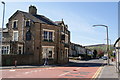
The Victoria, Darwen
Situated on Sudell Road away from the town centre.
Image: © Bill Boaden
Taken: 9 Apr 2011
0.07 miles
2
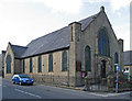
Darwen - Congregational Church
On Highfield Road.
Image: © Dave Bevis
Taken: 21 Jul 2014
0.08 miles
3
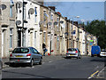
Ellison Fold Terrace, Darwen
On the opposite side of the valley you can see the terrace on Punstock Road.
Image: © Bill Boaden
Taken: 9 Apr 2011
0.10 miles
4
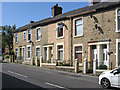
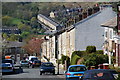
Darwen - houses on west side of Highfield Road
Image: © Dave Bevis
Taken: 21 Jul 2014
0.10 miles
6
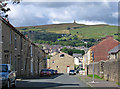
Darwen - view down Philip Street
And across to Jubilee Tower.
Image: © Dave Bevis
Taken: 21 Jul 2014
0.14 miles
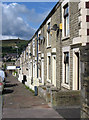
7

Kay Street, Darwen
Residential street in the old Lancashire town of Darwen
Image: © Chris Heaton
Taken: 15 Jan 2022
0.18 miles
8

Back Alley heading South off Ratcliffe Street, Darwen
Short alleyway, leading to a dead end at the railway lines
Image: © Chris Heaton
Taken: 15 Jan 2022
0.19 miles
9
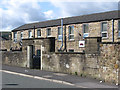
Darwen - office furniture works on Ratcliffe Street
Image: © Dave Bevis
Taken: 21 Jul 2014
0.19 miles