IMAGES TAKEN NEAR TO
Bull Hill Lane, DARWEN, BB3 3FS
Introduction
This page details the photographs taken nearby to Bull Hill Lane, BB3 3FS by members of the Geograph project.
The Geograph project started in 2005 with the aim of publishing, organising and preserving representative images for every square kilometre of Great Britain, Ireland and the Isle of Man.

There are currently over 7.5m images from over14,400 individuals and you can help contribute to the project by visiting https://www.geograph.org.uk
Image Map
Images are licensed for reuse under creativecommons.org/licenses/by-sa/2.0
Notes
- Clicking on the map will re-center to the selected point.
- The higher the marker number, the further away the image location is from the centre of the postcode.
Image Listing (16 Images Found)
Images are licensed for reuse under creativecommons.org/licenses/by-sa/2.0
Image
Details
Distance
1

Top of the Meadow Farm
This also shows its aspect to the west. I don't think there's a lot of farming going on from here.
Image: © Bill Boaden
Taken: 21 Aug 2010
0.01 miles
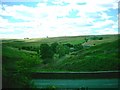
2
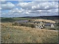
Top o' t' Meadow Farm, Entwistle, Darwen
Taken from above, looking down towards the farm with Whittlestone Head and Grimehills in background. Also the Roman Road running towards Blacksnape.
Image: © Eileen Cowen
Taken: 5 Apr 2006
0.03 miles
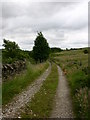
3

Field below Top of the Meadow Farm
The path doesn't follow the drive at the bottom end but joins it halfway up, after crossing the lower part of this field. The bale in the foreground must have been pecked before time.
Image: © Bill Boaden
Taken: 21 Aug 2010
0.07 miles
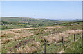
5
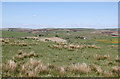
Upland scenery near Ramwells Farm
Looking across Grimehills to Hoddlesden Moss with Edgerton Moss on the skyline.
Image: © Alan Murray-Rust
Taken: 4 Jun 2013
0.15 miles
7
Whittlestone Head
The reference is for the group of cottages/houses in the centre of the photo,
Image: © John Lomas
Taken: 7 Aug 2005
0.16 miles
8
Upland scenery near Cranberry Moss
Looking down the valley of the Whittlestone Head Brook. In the blue yonder, the Pennine moors above Oldham. The birds in flight are skylarks.
Image: © Alan Murray-Rust
Taken: 4 Jun 2013
0.17 miles
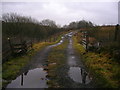
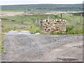
10

The railway cutting at Whittle Head
There is a track at the bottom of this cutting, but it is not visible because of the verdant undergrowth. The track enters the tunnel just to the left.
Image: © Bill Boaden
Taken: 21 Aug 2010
0.18 miles