IMAGES TAKEN NEAR TO
Whitehall Road, DARWEN, BB3 2LH
Introduction
This page details the photographs taken nearby to Whitehall Road, BB3 2LH by members of the Geograph project.
The Geograph project started in 2005 with the aim of publishing, organising and preserving representative images for every square kilometre of Great Britain, Ireland and the Isle of Man.

There are currently over 7.5m images from over14,400 individuals and you can help contribute to the project by visiting https://www.geograph.org.uk
Image Map
Images are licensed for reuse under creativecommons.org/licenses/by-sa/2.0
Notes
- Clicking on the map will re-center to the selected point.
- The higher the marker number, the further away the image location is from the centre of the postcode.
Image Listing (8 Images Found)
Images are licensed for reuse under creativecommons.org/licenses/by-sa/2.0
Image
Details
Distance
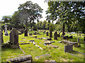
1
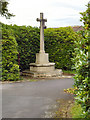
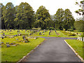
Darwen Old Cemetery
On the hill beside Whitehall Park. This is only used now for already existing graves, and the newer section is on the other side of Bolton Road.
Image: © Bill Boaden
Taken: 9 Feb 2013
0.14 miles
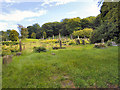
2
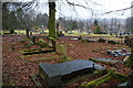
Darwen Cemetery, West
There are many toppled gravestones in the cemetery. Whether this is because of vandalism or natural causes, I don't know.
Image: © philandju
Taken: 20 Nov 2014
0.15 miles
5
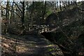
Footbridge over Buryfold Brook
Crossing a small footbridge in a tight wooded clough
Image: © Chris Heaton
Taken: 5 Mar 2022
0.21 miles
7
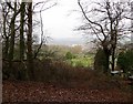
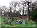
At the top of Darwen Cemetery
Looking down from a leaf strewn footpath.
Image: © philandju
Taken: 20 Nov 2014
0.23 miles