IMAGES TAKEN NEAR TO
Cranberry Fold, DARWEN, BB3 2HU
Introduction
This page details the photographs taken nearby to Cranberry Fold, BB3 2HU by members of the Geograph project.
The Geograph project started in 2005 with the aim of publishing, organising and preserving representative images for every square kilometre of Great Britain, Ireland and the Isle of Man.

There are currently over 7.5m images from over14,400 individuals and you can help contribute to the project by visiting https://www.geograph.org.uk
Image Map
Images are licensed for reuse under creativecommons.org/licenses/by-sa/2.0
Notes
- Clicking on the map will re-center to the selected point.
- The higher the marker number, the further away the image location is from the centre of the postcode.
Image Listing (4 Images Found)
Images are licensed for reuse under creativecommons.org/licenses/by-sa/2.0
Image
Details
Distance
1
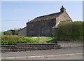
Farmhouse at Cranberry Fold
Now a house with a small garden.
Image: © Phil Platt
Taken: 19 Apr 2011
0.02 miles
2
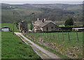
New Meadows Gap Farmhouse
The gable end facing the camera position is of New Meadows Gap Cottage, which is attached to the farmhouse. The main farming activity seems to be horses.
Image: © Phil Platt
Taken: 19 Apr 2011
0.13 miles
3
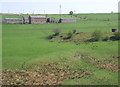
Hampson's Farm
From pasture land north of Bent Hall Farm. The structure on the right midground is a disused shaft. Presumably, an air shaft for a coal mine.
Image: © Phil Platt
Taken: 19 Apr 2011
0.16 miles
4
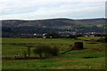
Ventilation Shaft above Sough Tunnel
Serves the mile long Sough Railway Tunnel on the Ribble Valley Line between Manchester and Clitheroe, via Blackburn
Image: © Chris Heaton
Taken: 15 Jan 2022
0.16 miles