IMAGES TAKEN NEAR TO
Clough Street, DARWEN, BB3 2ER
Introduction
This page details the photographs taken nearby to Clough Street, BB3 2ER by members of the Geograph project.
The Geograph project started in 2005 with the aim of publishing, organising and preserving representative images for every square kilometre of Great Britain, Ireland and the Isle of Man.

There are currently over 7.5m images from over14,400 individuals and you can help contribute to the project by visiting https://www.geograph.org.uk
Image Map
Images are licensed for reuse under creativecommons.org/licenses/by-sa/2.0
Notes
- Clicking on the map will re-center to the selected point.
- The higher the marker number, the further away the image location is from the centre of the postcode.
Image Listing (12 Images Found)
Images are licensed for reuse under creativecommons.org/licenses/by-sa/2.0
Image
Details
Distance

2
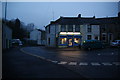
Village shop in Spring Vale
Viewed from the bottom of Cranberry Lane.
Image: © Bill Boaden
Taken: 9 Feb 2013
0.09 miles
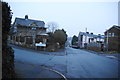
3
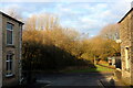
On Dewhurst Street, Darwen
Dewhurst Street entering Watery Lane
Image: © Chris Heaton
Taken: 15 Jan 2022
0.10 miles
4
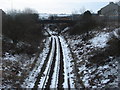
Railway at Sough/Spring Vale/Rosehill area of Darwen
One of the points where a crossroads crosses over the railway line.
Image: © Margaret Clough
Taken: 13 Mar 2006
0.10 miles

7
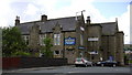
The Borough Hotel, Grimshaw Street, Darwen
Image: © Robert Wade
Taken: 23 Jul 2009
0.15 miles
8
Top entrance of Spring Vale Garden Village
This is where it leaves Cranberry Lane. It is a new housing development with an overstated name.
Image: © Bill Boaden
Taken: 9 Feb 2013
0.20 miles
9
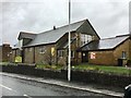
St Barnabas' Parish Church, Watery Lane, Darwen
Image: © John H Darch
Taken: 27 Nov 2017
0.21 miles
10

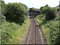
Footpath heading for Sough, Darwen
Follows the railway very closely - so closely in fact, that it is a squeeze between hedge vegetation and the rail boundary wall.
Image: © Chris Heaton
Taken: 15 Jan 2022
0.21 miles