IMAGES TAKEN NEAR TO
Broken Stone Road, DARWEN, BB3 0LL
Introduction
This page details the photographs taken nearby to Broken Stone Road, BB3 0LL by members of the Geograph project.
The Geograph project started in 2005 with the aim of publishing, organising and preserving representative images for every square kilometre of Great Britain, Ireland and the Isle of Man.

There are currently over 7.5m images from over14,400 individuals and you can help contribute to the project by visiting https://www.geograph.org.uk
Image Map (Loading...)


Getting Data...Please wait
Leaflet Map data © OpenStreetMap
Images are licensed for reuse under creativecommons.org/licenses/by-sa/2.0
Notes
- Clicking on the map will re-center to the selected point.
- The higher the marker number, the further away the image location is from the centre of the postcode.
Image Listing (3 Images Found)
Images are licensed for reuse under creativecommons.org/licenses/by-sa/2.0
Image
Details
Distance
1
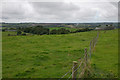
Looking towards Yew Tree farm
In the background is the gentle roar of traffic speeding along the M65.
Image: © Mr T
Taken: 1 Sep 2007
0.19 miles
2
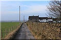
Coppice Farm
Access lane leading towards the farm from Tockholes Road
Image: © Chris Heaton
Taken: 8 Jan 2020
0.21 miles
3
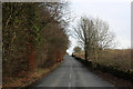
Ascending Broken Stone Road
Long gradual climb up Broken Stone Road from Feniscowles
Image: © Chris Heaton
Taken: 8 Jan 2020
0.22 miles