IMAGES TAKEN NEAR TO
Bog Height Road, DARWEN, BB3 0LG
Introduction
This page details the photographs taken nearby to Bog Height Road, BB3 0LG by members of the Geograph project.
The Geograph project started in 2005 with the aim of publishing, organising and preserving representative images for every square kilometre of Great Britain, Ireland and the Isle of Man.

There are currently over 7.5m images from over14,400 individuals and you can help contribute to the project by visiting https://www.geograph.org.uk
Image Map (Loading...)


Getting Data...Please wait
Leaflet Map data © OpenStreetMap
Images are licensed for reuse under creativecommons.org/licenses/by-sa/2.0
Notes
- Clicking on the map will re-center to the selected point.
- The higher the marker number, the further away the image location is from the centre of the postcode.
Image Listing (33 Images Found)
Images are licensed for reuse under creativecommons.org/licenses/by-sa/2.0
Image
Details
Distance
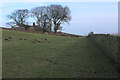
1
Peak Brow
There were sheep grazing in this field. In the next, just over the wall on the right, was a Longhorn Bull Image
Image: © Mr T
Taken: 1 Sep 2007
0.07 miles
2
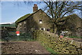
Bog Bank Farm
The sign makes it clear that there is no path through the farm, although there is one marked on my map.
Image: © Bill Boaden
Taken: 9 Apr 2011
0.10 miles
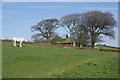
6
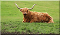
Sitting on the grass
I'm unsure if this was a bull or not, but as there were no other cattle to be seen in the field I hoped not.
Image: © Mr T
Taken: 1 Sep 2007
0.13 miles
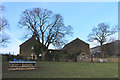
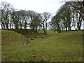
7
Approaching Bog Bank Farm
The footpath follows the stone wall before leaving the pasture through the open gateway
Image: © Chris Heaton
Taken: 8 Jan 2020
0.13 miles
9

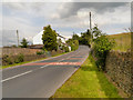
Heys Lane
The road towards Blackburn from Image
Image: © David Dixon
Taken: 12 Jul 2012
0.17 miles
10

Black Bull
The Black Bull public house at the crossroads of Bog Height Road, Broken Stone Road, Heys Lane and Tockholes Road.
Image: © David Dixon
Taken: 12 Jul 2012
0.18 miles