IMAGES TAKEN NEAR TO
Bog Height Road, DARWEN, BB3 0LF
Introduction
This page details the photographs taken nearby to Bog Height Road, BB3 0LF by members of the Geograph project.
The Geograph project started in 2005 with the aim of publishing, organising and preserving representative images for every square kilometre of Great Britain, Ireland and the Isle of Man.

There are currently over 7.5m images from over14,400 individuals and you can help contribute to the project by visiting https://www.geograph.org.uk
Image Map (Loading...)


Getting Data...Please wait
Leaflet Map data © OpenStreetMap
Images are licensed for reuse under creativecommons.org/licenses/by-sa/2.0
Notes
- Clicking on the map will re-center to the selected point.
- The higher the marker number, the further away the image location is from the centre of the postcode.
Image Listing (25 Images Found)
Images are licensed for reuse under creativecommons.org/licenses/by-sa/2.0
Image
Details
Distance

2
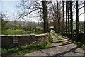
The tree-lined entrance to Spout House Farm
Image: © Bill Boaden
Taken: 9 Apr 2011
0.05 miles
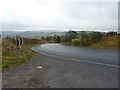
4
A sharp bend in the road approaching Earcroft
Image: © Ian Greig
Taken: 17 Jun 2011
0.10 miles

6
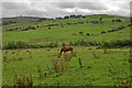
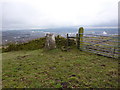
Field below Meadow Head Lane
On the left horizon you can make out Image, but what you can't see is the M65 running through the middle of the picture. You can hear it though.
Image: © Mr T
Taken: 1 Sep 2007
0.11 miles
7
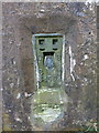
Fernhurst Trig Pillar, Flush bracket
Image: © Alexander P Kapp
Taken: 17 Mar 2011
0.12 miles

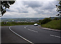
10
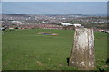
Trig point overlooking Blackburn
The town centre is in the centre background while Ewood Park football stadium is this side of it.
Image: © Bill Boaden
Taken: 9 Apr 2011
0.13 miles