IMAGES TAKEN NEAR TO
Preston New Road, BLACKBURN, BB2 7PU
Introduction
This page details the photographs taken nearby to Preston New Road, BB2 7PU by members of the Geograph project.
The Geograph project started in 2005 with the aim of publishing, organising and preserving representative images for every square kilometre of Great Britain, Ireland and the Isle of Man.

There are currently over 7.5m images from over14,400 individuals and you can help contribute to the project by visiting https://www.geograph.org.uk
Image Map
Images are licensed for reuse under creativecommons.org/licenses/by-sa/2.0
Notes
- Clicking on the map will re-center to the selected point.
- The higher the marker number, the further away the image location is from the centre of the postcode.
Image Listing (10 Images Found)
Images are licensed for reuse under creativecommons.org/licenses/by-sa/2.0
Image
Details
Distance
1
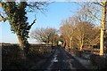
Park Lane, Mellor Brook
Bridleway that runs parallel and slightly south of the A677 Preston New Road in Mellor Brook
Image: © Chris Heaton
Taken: 29 Nov 2019
0.07 miles
2
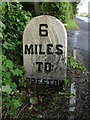
Old Milestone by the A677, Mellor Brook, Samlesbury parish
Carved stone post by the A677, in parish of SAMLESBURY (SOUTH RIBBLE District), Mellor Brook, near Higher Park Farm, on South side of road. Salmesbury stone, erected by the Blackburn & Preston turnpike trust in the 19th century.
Inscription reads:-
: 6 / MILES / TO / PRESTON / (SAMLESBURY) : : 3¾ / MILES / TO / (BLACKBURN / SAMLESBURY) :
Milestone Society National ID: LA_PSBBA06.
Image: © J Higgins
Taken: 1 May 2009
0.08 miles
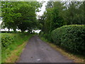
4

Preston New Road, Mellor Brook
The A677.
Image: © David Dixon
Taken: 24 Jun 2015
0.16 miles
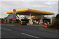

7

Shell Filling Station on Preston New Road
The Windmill filling station at the junction of Intack Lane with Preston New Road (A677).
Image: © David Dixon
Taken: 24 Jun 2015
0.19 miles
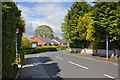
8
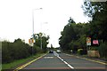
Preston New Road entering Mellor Brook
Image: © Steve Daniels
Taken: 28 Aug 2014
0.19 miles
9

Windmill Petrol Station, Mellor Brook
Shell filling station on the A677, Preston New Road at Mellor Brook.
Image: © David Dixon
Taken: 24 Jun 2015
0.19 miles