IMAGES TAKEN NEAR TO
Preston New Road, BLACKBURN, BB2 7NR
Introduction
This page details the photographs taken nearby to Preston New Road, BB2 7NR by members of the Geograph project.
The Geograph project started in 2005 with the aim of publishing, organising and preserving representative images for every square kilometre of Great Britain, Ireland and the Isle of Man.

There are currently over 7.5m images from over14,400 individuals and you can help contribute to the project by visiting https://www.geograph.org.uk
Image Map
Images are licensed for reuse under creativecommons.org/licenses/by-sa/2.0
Notes
- Clicking on the map will re-center to the selected point.
- The higher the marker number, the further away the image location is from the centre of the postcode.
Image Listing (9 Images Found)
Images are licensed for reuse under creativecommons.org/licenses/by-sa/2.0
Image
Details
Distance
1
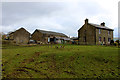
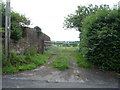
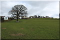
Brundhurst Farm
Farming operation located midway between the communities of Mellor and Mellor Brook.
A public footpath crosses the pasture, running between the farm buildings - emerging the other side en route for Mellor.
Image: © Chris Heaton
Taken: 20 Mar 2018
0.01 miles
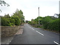
4
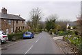
Mellor Brow
A steep descent from Mellor.
Image: © Richard Webb
Taken: 4 Apr 2019
0.16 miles
8
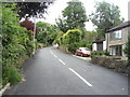
Heading uphill on Mellor Brow, Mellor Brook
Image: © JThomas
Taken: 16 Jul 2016
0.19 miles
9
Approaching Mellor from Brundhurst Farm
The public footpath adopts the muddy track as far as Mellor Brow
Image: © Chris Heaton
Taken: 20 Mar 2018
0.19 miles