IMAGES TAKEN NEAR TO
St. Marys Gardens, BLACKBURN, BB2 7JW
Introduction
This page details the photographs taken nearby to St. Marys Gardens, BB2 7JW by members of the Geograph project.
The Geograph project started in 2005 with the aim of publishing, organising and preserving representative images for every square kilometre of Great Britain, Ireland and the Isle of Man.

There are currently over 7.5m images from over14,400 individuals and you can help contribute to the project by visiting https://www.geograph.org.uk
Image Map
Images are licensed for reuse under creativecommons.org/licenses/by-sa/2.0
Notes
- Clicking on the map will re-center to the selected point.
- The higher the marker number, the further away the image location is from the centre of the postcode.
Image Listing (49 Images Found)
Images are licensed for reuse under creativecommons.org/licenses/by-sa/2.0
Image
Details
Distance
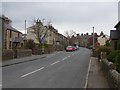
2
Mellor Community Centre
Ugly but very useful.
Image: © Mike and Kirsty Grundy
Taken: 21 Aug 2005
0.08 miles
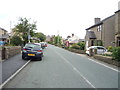
4
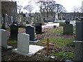
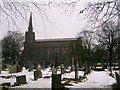
The Parish Church of St Mary the Virgin, Mellor, Graveyard
Image: © Alexander P Kapp
Taken: 5 Dec 2008
0.11 miles
7
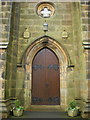
The Parish Church of St Mary the Virgin, Mellor, Doorway
Image: © Alexander P Kapp
Taken: 8 Dec 2008
0.12 miles
8
The Parish Church of St Mary the Virgin, Mellor
Image: © Alexander P Kapp
Taken: 5 Dec 2008
0.12 miles
9
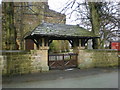
The Parish Church of St Mary the Virgin, Mellor, Lychgate
Image: © Alexander P Kapp
Taken: 8 Dec 2008
0.12 miles
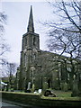
10
Parish Church of St Mary the Virgin, Mellor
A Commissioners' church of 1829.
Image: © John H Darch
Taken: 4 Dec 2010
0.12 miles