IMAGES TAKEN NEAR TO
Brundhurst Fold, BLACKBURN, BB2 7JT
Introduction
This page details the photographs taken nearby to Brundhurst Fold, BB2 7JT by members of the Geograph project.
The Geograph project started in 2005 with the aim of publishing, organising and preserving representative images for every square kilometre of Great Britain, Ireland and the Isle of Man.

There are currently over 7.5m images from over14,400 individuals and you can help contribute to the project by visiting https://www.geograph.org.uk
Image Map
Images are licensed for reuse under creativecommons.org/licenses/by-sa/2.0
Notes
- Clicking on the map will re-center to the selected point.
- The higher the marker number, the further away the image location is from the centre of the postcode.
Image Listing (42 Images Found)
Images are licensed for reuse under creativecommons.org/licenses/by-sa/2.0
Image
Details
Distance
3
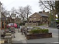
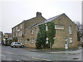
Mellor Lane
Outside the Millstone, Mellor
Image: © Richard Webb
Taken: 4 Apr 2019
0.05 miles
4
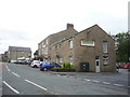
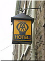
Millstone at Mellor
Village Inn & Restaurant.
Image: © JThomas
Taken: 16 Jul 2016
0.05 miles
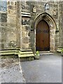
5
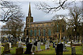
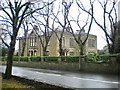
Church of St. Mary the Virgin, Mellor
Anglican parish church, serving the ecclesiastical needs for the community of Mellor.
Image: © Chris Heaton
Taken: 20 Mar 2018
0.06 miles
7
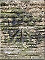
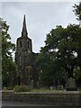
OS Cut Mark - Mellor, St Mary Church
https://www.bench-marks.org.uk/bm58946
Image: © thejackrustles
Taken: 8 Jul 2022
0.06 miles
8
Location of OS Cut Mark - Mellor, St Mary Church
Image: © thejackrustles
Taken: 8 Jul 2022
0.06 miles