IMAGES TAKEN NEAR TO
Whitecroft Lane, BLACKBURN, BB2 7HA
Introduction
This page details the photographs taken nearby to Whitecroft Lane, BB2 7HA by members of the Geograph project.
The Geograph project started in 2005 with the aim of publishing, organising and preserving representative images for every square kilometre of Great Britain, Ireland and the Isle of Man.

There are currently over 7.5m images from over14,400 individuals and you can help contribute to the project by visiting https://www.geograph.org.uk
Image Map
Images are licensed for reuse under creativecommons.org/licenses/by-sa/2.0
Notes
- Clicking on the map will re-center to the selected point.
- The higher the marker number, the further away the image location is from the centre of the postcode.
Image Listing (18 Images Found)
Images are licensed for reuse under creativecommons.org/licenses/by-sa/2.0
Image
Details
Distance
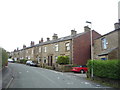
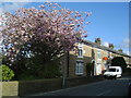
1
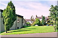
A piece of village green at Mellor
A quiet corner of the village on Whitecroft Lane.
Image: © Bill Boaden
Taken: 17 Mar 2012
0.05 miles
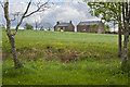
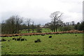
3
Deer near Mellor
A pair of deer scampered up the hillside and disappeared almsot immediately.
Image: © Bill Boaden
Taken: 17 Mar 2012
0.18 miles
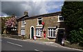
4
Mellor Post Office
Set in the heart of the village, Mellor Post Office contributes strongly to the quality of village life
Image: © Richard Jones
Taken: 3 May 2004
0.19 miles
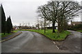
5
Path to Mellor
Not clearly defined. The next part is very squelchy at this time of year.
Image: © Bill Boaden
Taken: 17 Mar 2012
0.21 miles
6
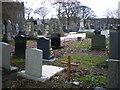
The Parish Church of St Mary the Virgin, Mellor, Graveyard
Image: © Alexander P Kapp
Taken: 5 Dec 2008
0.22 miles
8
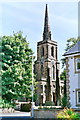
Mellor Parish Church (St Mary the Virgin)
Beautifully proportioned ? Georgian
Image: © Mike and Kirsty Grundy
Taken: 21 Aug 2005
0.23 miles
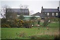
9
Mellor Community Centre
Ugly but very useful.
Image: © Mike and Kirsty Grundy
Taken: 21 Aug 2005
0.23 miles