IMAGES TAKEN NEAR TO
Alberta Close, BLACKBURN, BB2 7DU
Introduction
This page details the photographs taken nearby to Alberta Close, BB2 7DU by members of the Geograph project.
The Geograph project started in 2005 with the aim of publishing, organising and preserving representative images for every square kilometre of Great Britain, Ireland and the Isle of Man.

There are currently over 7.5m images from over14,400 individuals and you can help contribute to the project by visiting https://www.geograph.org.uk
Image Map
Images are licensed for reuse under creativecommons.org/licenses/by-sa/2.0
Notes
- Clicking on the map will re-center to the selected point.
- The higher the marker number, the further away the image location is from the centre of the postcode.
Image Listing (7 Images Found)
Images are licensed for reuse under creativecommons.org/licenses/by-sa/2.0
Image
Details
Distance
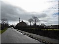
3
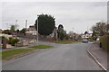
Whinney Lane, Blackburn
Approaching the ring road.
Image: © Richard Webb
Taken: 4 Apr 2019
0.13 miles
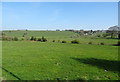
4
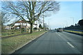
A6119 Yew Tree Drive
The A6119:- Here named Yew Tree Drive, which changes to Ramsgreave Drive after the junction of Lammack Road/Barker Lane shortly over the rise in the distance.
(It later becomes Brownhill drive, Whitebirk Drive then Whitebirk Road at Intack.)
Image: © Tony Mercer
Taken: 25 Jan 2009
0.16 miles
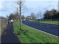
7
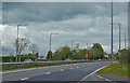
The ring road with illuminated speed warning sign
Image: © Ian Greig
Taken: 24 May 2013
0.23 miles