IMAGES TAKEN NEAR TO
Billinge End Road, BLACKBURN, BB2 6QZ
Introduction
This page details the photographs taken nearby to Billinge End Road, BB2 6QZ by members of the Geograph project.
The Geograph project started in 2005 with the aim of publishing, organising and preserving representative images for every square kilometre of Great Britain, Ireland and the Isle of Man.

There are currently over 7.5m images from over14,400 individuals and you can help contribute to the project by visiting https://www.geograph.org.uk
Image Map
Images are licensed for reuse under creativecommons.org/licenses/by-sa/2.0
Notes
- Clicking on the map will re-center to the selected point.
- The higher the marker number, the further away the image location is from the centre of the postcode.
Image Listing (6 Images Found)
Images are licensed for reuse under creativecommons.org/licenses/by-sa/2.0
Image
Details
Distance
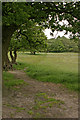
1
Witton Weavers Way heading West from Gorton Wood
The long distance footpath heads across a series of pastures to Billinge End Road
Image: © Chris Heaton
Taken: 8 Sep 2019
0.07 miles
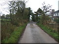
2
Witton Weavers Way
Looking towards Moorside and Gorton Wood
Image: © Mr T
Taken: 27 May 2007
0.10 miles
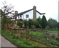
3
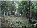
Gorton Wood
A tumbledown wall gives views of the new fencing in Gorton Wood below the Old School House in Pleasington.
Image: © Greum
Taken: 4 Aug 2022
0.11 miles
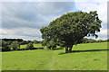
4

Hay bales at Maiden House Farm
Hay bales on the field crossed by the Witton Weaver's Way, with Maiden House Farm visible in the background.
Image: © Greum
Taken: 30 May 2020
0.14 miles