IMAGES TAKEN NEAR TO
BB2 5LU
Introduction
This page details the photographs taken nearby to BB2 5LU by members of the Geograph project.
The Geograph project started in 2005 with the aim of publishing, organising and preserving representative images for every square kilometre of Great Britain, Ireland and the Isle of Man.

There are currently over 7.5m images from over14,400 individuals and you can help contribute to the project by visiting https://www.geograph.org.uk
Image Map
Images are licensed for reuse under creativecommons.org/licenses/by-sa/2.0
Notes
- Clicking on the map will re-center to the selected point.
- The higher the marker number, the further away the image location is from the centre of the postcode.
Image Listing (4 Images Found)
Images are licensed for reuse under creativecommons.org/licenses/by-sa/2.0
Image
Details
Distance
1

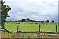
Horden Farm
Farm off Broken Stone Road, and passed by the Witton Weavers Way long distance footpath
Image: © Chris Heaton
Taken: 8 Jan 2020
0.15 miles
2
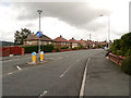
Livesey Branch Road
Livesey Branch Road (A6062), Feniscowles
Image: © David Dixon
Taken: 29 Jul 2012
0.20 miles
3
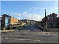
Moorland Drive, Green Hills, Livesey
Looking up Moorland Drive, entrance to the recently-built Green Hills estate.
Image: © Greum
Taken: 25 Sep 2021
0.22 miles
4
Fowler Fold from Horden Rake, Livesey, Blackburn
Image: © Mike and Kirsty Grundy
Taken: 28 Aug 2005
0.22 miles