IMAGES TAKEN NEAR TO
Preston Old Road, BLACKBURN, BB2 5HD
Introduction
This page details the photographs taken nearby to Preston Old Road, BB2 5HD by members of the Geograph project.
The Geograph project started in 2005 with the aim of publishing, organising and preserving representative images for every square kilometre of Great Britain, Ireland and the Isle of Man.

There are currently over 7.5m images from over14,400 individuals and you can help contribute to the project by visiting https://www.geograph.org.uk
Image Map
Images are licensed for reuse under creativecommons.org/licenses/by-sa/2.0
Notes
- Clicking on the map will re-center to the selected point.
- The higher the marker number, the further away the image location is from the centre of the postcode.
Image Listing (42 Images Found)
Images are licensed for reuse under creativecommons.org/licenses/by-sa/2.0
Image
Details
Distance
1

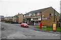
Shops on Kentmere Drive, Cherry Tree
Showing position of Postbox No. BB2 135.
See Image] for postbox.
Image: © JThomas
Taken: 25 Oct 2018
0.00 miles
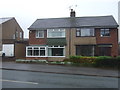
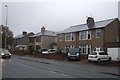
2
Kentmere Drive
Leading to housing off Preston Old Road, with a couple of shops at the end.
Image: © Bill Boaden
Taken: 15 Mar 2012
0.01 miles
3
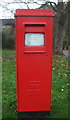
Elizabeth II postbox on Kentmere Drive, Cherry Tree
Image: © JThomas
Taken: 25 Oct 2018
0.01 miles
4
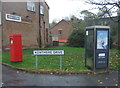
Elizabeth II postbox and telephone box on Kentmere Drive, Cherry Tree
Postbox No. BB2 135.
See Image] for postbox.
Image: © JThomas
Taken: 25 Oct 2018
0.01 miles
6
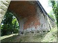
The Three Arches, Feniscowles
A close look under the northernmost arch of the disused viaduct known locally as the Three Arches.
The bridge formerly carried the Lancashire Union Railway, built in the latter part of the 1860s to provide a direct connection between Blackburn and the rest of the East Lancashire cotton towns to sources of coal in and around Chorley and Wigan.
The line was eventually closed in January 1966, though the section between Cherry Tree and Feniscowles survived until 1968.
There's a good overview on the White Coppice, Anglezarke & Rivington website (exceptional local resource) at http://www.white-coppice.co.uk/chorley_blackburn.htm.
Image: © Greum
Taken: 7 Jun 2023
0.04 miles
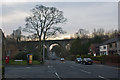
10
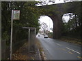
Bus stop and shelter on Preston Old Road
Disused railway viaduct behind.
Image: © JThomas
Taken: 25 Oct 2018
0.06 miles