IMAGES TAKEN NEAR TO
Heys Lane, BLACKBURN, BB2 4NW
Introduction
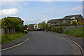
This page details the photographs taken nearby to Heys Lane, BB2 4NW by members of the Geograph project.
The Geograph project started in 2005 with the aim of publishing, organising and preserving representative images for every square kilometre of Great Britain, Ireland and the Isle of Man.

There are currently over 7.5m images from over14,400 individuals and you can help contribute to the project by visiting https://www.geograph.org.uk
Image Map
Images are licensed for reuse under creativecommons.org/licenses/by-sa/2.0
Notes
- Clicking on the map will re-center to the selected point.
- The higher the marker number, the further away the image location is from the centre of the postcode.
Image Listing (13 Images Found)
Images are licensed for reuse under creativecommons.org/licenses/by-sa/2.0
Image
Details
Distance
1
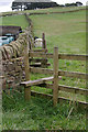
New Stile
The old one can be seen just behind abutting the wall. On the other side of the wall was a chicken coop.
Image: © Mr T
Taken: 1 Sep 2007
0.06 miles
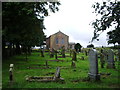
4
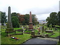
New Row Methodist Church, Graveyard
Image: © Alexander P Kapp
Taken: 29 Sep 2008
0.11 miles
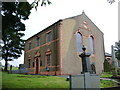
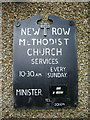
6
New Row Methodist Church, Livesey, near Blackburn
Early 19th century Wesleyan Methodist Chapel on Heys Lane, near Bank Hey. Very large graveyard with many old gravestones. Listed building.
Image: © Eileen Cowen
Taken: 11 Mar 2007
0.11 miles
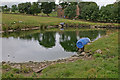
10

Sitting on the grass
I'm unsure if this was a bull or not, but as there were no other cattle to be seen in the field I hoped not.
Image: © Mr T
Taken: 1 Sep 2007
0.16 miles