IMAGES TAKEN NEAR TO
Newmeadow Close, BLACKBURN, BB2 3WY
Introduction
This page details the photographs taken nearby to Newmeadow Close, BB2 3WY by members of the Geograph project.
The Geograph project started in 2005 with the aim of publishing, organising and preserving representative images for every square kilometre of Great Britain, Ireland and the Isle of Man.

There are currently over 7.5m images from over14,400 individuals and you can help contribute to the project by visiting https://www.geograph.org.uk
Image Map
Images are licensed for reuse under creativecommons.org/licenses/by-sa/2.0
Notes
- Clicking on the map will re-center to the selected point.
- The higher the marker number, the further away the image location is from the centre of the postcode.
Image Listing (17 Images Found)
Images are licensed for reuse under creativecommons.org/licenses/by-sa/2.0
Image
Details
Distance
3
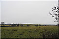
Fields up to Fishmoor Reservoir
The dam wall is clear at the top of the hill. To the right is the JJB Soccerdome, as still commonly referred to, though I think it is now called the DW Sports Fitness Centre.
Image: © Bill Boaden
Taken: 12 Jan 2011
0.15 miles
4
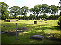
St James's Church, Blackamoor, Graveyard
Image: © Alexander P Kapp
Taken: 7 Aug 2009
0.15 miles
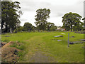
6
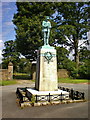
War Memorial and Cemetery
The War Memorial and cemetery attached to Image
Image: © David Dixon
Taken: 20 Jul 2011
0.15 miles
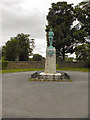
8
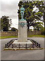
St James' War Memorial, Lower Darwen
Image: © David Dixon
Taken: 20 Jul 2011
0.16 miles
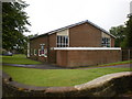
9
St James' Church, Lower Darwen
Founded in 1826, St James, Lower Darwen was built at the top of Stopes Brow. The foundation stone was laid on 22nd February 1827 and the church was consecrated on the 15th March 1829. The old church was demolished in 1969 due to wet rot and the modern Church was built in its place. (http://www.genuki.org.uk/big/eng/LAN/LowerDarwen/StJames.shtml )
Image: © David Dixon
Taken: 20 Jul 2011
0.16 miles
10

Crossroads on Roman Road
A busy junction, and the fast phasing of the traffic lights causes queues for those trying to cross between Blackamoor Road and Stopes Brow.
Image: © Bill Boaden
Taken: 12 Jan 2011
0.18 miles