IMAGES TAKEN NEAR TO
Faroes Close, BLACKBURN, BB2 3EL
Introduction
This page details the photographs taken nearby to Faroes Close, BB2 3EL by members of the Geograph project.
The Geograph project started in 2005 with the aim of publishing, organising and preserving representative images for every square kilometre of Great Britain, Ireland and the Isle of Man.

There are currently over 7.5m images from over14,400 individuals and you can help contribute to the project by visiting https://www.geograph.org.uk
Image Map
Images are licensed for reuse under creativecommons.org/licenses/by-sa/2.0
Notes
- Clicking on the map will re-center to the selected point.
- The higher the marker number, the further away the image location is from the centre of the postcode.
Image Listing (7 Images Found)
Images are licensed for reuse under creativecommons.org/licenses/by-sa/2.0
Image
Details
Distance
2
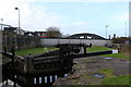
Blackburn Lock and Hall Street Bridge
Hall Street Bridge, No.99A on the Leeds and Liverpool arguably the least attractive along the entire canal - a concrete carbunkle.
Image: © Chris Heaton
Taken: 8 Jan 2020
0.19 miles
3
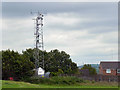
Mobile Phone Mast Behind Roman Road
Mobile phone mast in the south east corner of Image]
Image: © David Dixon
Taken: 20 Jul 2011
0.20 miles