IMAGES TAKEN NEAR TO
Selous Road, BLACKBURN, BB2 2TN
Introduction
This page details the photographs taken nearby to Selous Road, BB2 2TN by members of the Geograph project.
The Geograph project started in 2005 with the aim of publishing, organising and preserving representative images for every square kilometre of Great Britain, Ireland and the Isle of Man.

There are currently over 7.5m images from over14,400 individuals and you can help contribute to the project by visiting https://www.geograph.org.uk
Image Map
Images are licensed for reuse under creativecommons.org/licenses/by-sa/2.0
Notes
- Clicking on the map will re-center to the selected point.
- The higher the marker number, the further away the image location is from the centre of the postcode.
Image Listing (24 Images Found)
Images are licensed for reuse under creativecommons.org/licenses/by-sa/2.0
Image
Details
Distance
3

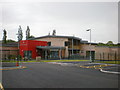
St Peter's RC Primary School, Sign
Image: © Alexander P Kapp
Taken: 18 May 2009
0.12 miles
4
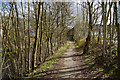
A tree lined path by the River Darwen
Included in the Witton Weavers Way
Image: © Ian Greig
Taken: 21 Mar 2014
0.16 miles
5
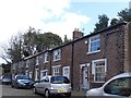
Springfield Street, Blackburn
Close to Griffin Park. The houses are grade 2 listed.
Image: © philandju
Taken: 17 Sep 2019
0.16 miles
6
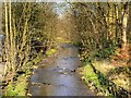
River Darwen, Mill Hill
The River Darwen, looking downstream from Mill Hill Bridge.
Image: © David Dixon
Taken: 23 Jul 2011
0.16 miles
7
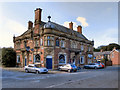
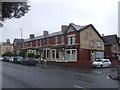
Mill Hill Hotel
The Mill Hill Hotel, on Mill Hill Bridge Street.
Image: © David Dixon
Taken: 23 Jul 2011
0.18 miles
8
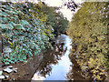
River Blakewater, Witton Park
Looking upstream from the bridge near the entrance to Witton Park, just before the Blakewater joins with the River Darwen.
Image: © David Dixon
Taken: 5 Apr 2015
0.18 miles
9
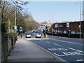
Preston Old Road
The A674 at the entrance to Witton Park.
Image: © David Dixon
Taken: 5 Apr 2015
0.18 miles
10
The main car park at Witton Park
It is closed for drainage work to be undertaken. The alternative car park is by King George's Playing Fields.
Image: © Bill Boaden
Taken: 17 Mar 2012
0.19 miles