IMAGES TAKEN NEAR TO
George Street West, BLACKBURN, BB2 1PQ
Introduction
This page details the photographs taken nearby to George Street West, BB2 1PQ by members of the Geograph project.
The Geograph project started in 2005 with the aim of publishing, organising and preserving representative images for every square kilometre of Great Britain, Ireland and the Isle of Man.

There are currently over 7.5m images from over14,400 individuals and you can help contribute to the project by visiting https://www.geograph.org.uk
Image Map
Images are licensed for reuse under creativecommons.org/licenses/by-sa/2.0
Notes
- Clicking on the map will re-center to the selected point.
- The higher the marker number, the further away the image location is from the centre of the postcode.
Image Listing (28 Images Found)
Images are licensed for reuse under creativecommons.org/licenses/by-sa/2.0
Image
Details
Distance
1
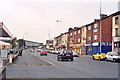
Bank Top, Blackburn
Uninspiring street scene (A674)
Image: © Mike and Kirsty Grundy
Taken: 28 Aug 2005
0.10 miles
4
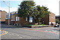
St Anne's Catholic , Blackburn
The west end of the church was damaged by fire. West wall was rebuilt, making the church half the size of the original.
Image: © Alexander P Kapp
Taken: 24 Sep 2005
0.11 miles
6
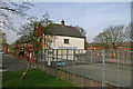
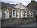
Blackburn Ragged School
Ragged schools began in the mid nineteenth century and offered free education to destitute children http://www.maybole.org/history/articles/historyofraggedschools.htm . The fenced playground is Bank Top Junior Recreation Area, opened in 1995 by Kenny Dalglish when he was the Manager of Blackburn Rovers.
Image: © Mr T
Taken: 13 Apr 2007
0.16 miles
8
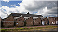
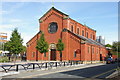
A mill with a traditional north light roof
This one does have the lights facing more or less north. A surprising number adopted the style but didn’t have the correct orientation – presumably due to the limitations of the available site.
Any space heating would be a steam pipe running under the gulley so that all the convected heat and 50% of the radiant heat was lost straight through the roof. The days of cheap fuel!
Image: © Ian Greig
Taken: 21 Mar 2014
0.19 miles
9
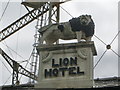
Lion Hotel, Wensley Road, Blackburn
Image: © Alexander P Kapp
Taken: 1 May 2008
0.20 miles
10
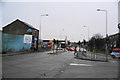
King Street, Blackburn
This is at the junction with Montague Street. King Street is the A674 which comes from Chorley, and it joins the inner ring road here. This used to be a box junction, but the markings have been covered up.
Image: © Bill Boaden
Taken: 12 Jan 2011
0.20 miles