IMAGES TAKEN NEAR TO
Pump Street, BLACKBURN, BB2 1PG
Introduction
This page details the photographs taken nearby to Pump Street, BB2 1PG by members of the Geograph project.
The Geograph project started in 2005 with the aim of publishing, organising and preserving representative images for every square kilometre of Great Britain, Ireland and the Isle of Man.

There are currently over 7.5m images from over14,400 individuals and you can help contribute to the project by visiting https://www.geograph.org.uk
Image Map
Images are licensed for reuse under creativecommons.org/licenses/by-sa/2.0
Notes
- Clicking on the map will re-center to the selected point.
- The higher the marker number, the further away the image location is from the centre of the postcode.
Image Listing (21 Images Found)
Images are licensed for reuse under creativecommons.org/licenses/by-sa/2.0
Image
Details
Distance
1
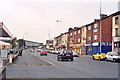
Bank Top, Blackburn
Uninspiring street scene (A674)
Image: © Mike and Kirsty Grundy
Taken: 28 Aug 2005
0.13 miles
2
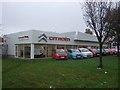
Car dealership, Blackburn
View from Bank Top.
Image: © JThomas
Taken: 25 Oct 2018
0.15 miles
3
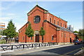
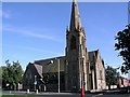
St Anne's Catholic , Blackburn
The west end of the church was damaged by fire. West wall was rebuilt, making the church half the size of the original.
Image: © Alexander P Kapp
Taken: 24 Sep 2005
0.15 miles
5
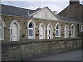
St Luke, Blackburn - Church of England
Situated on Bank Top at the junction with Stansfield Street Blackburn, still in use when this image was taken.
Image: © Steve Houldsworth
Taken: Unknown
0.15 miles
7
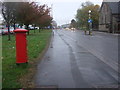
Bank Top, Blackburn
Showing position of Postbox No. BB2 91.
See Image] for postbox.
Image: © JThomas
Taken: 25 Oct 2018
0.16 miles
8
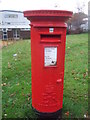
Elizabeth II postbox on Bank Top, Blackburn
Postbox No. BB2 91.
See Image] for context.
Image: © JThomas
Taken: 25 Oct 2018
0.16 miles
9
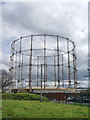
Run out of gas
The gasometer on Wensley Road, Blackburn with plenty of storage available
Image: © Alexander P Kapp
Taken: 1 May 2008
0.18 miles
10
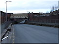
Railway bridge-Galligreaves St
Road under bridge which used to carry lines to coal sidings near to King St.
Image: © Tony Mercer
Taken: 1 Feb 2009
0.18 miles