IMAGES TAKEN NEAR TO
Holly Street, BLACKBURN, BB1 9TS
Introduction
This page details the photographs taken nearby to Holly Street, BB1 9TS by members of the Geograph project.
The Geograph project started in 2005 with the aim of publishing, organising and preserving representative images for every square kilometre of Great Britain, Ireland and the Isle of Man.

There are currently over 7.5m images from over14,400 individuals and you can help contribute to the project by visiting https://www.geograph.org.uk
Image Map
Images are licensed for reuse under creativecommons.org/licenses/by-sa/2.0
Notes
- Clicking on the map will re-center to the selected point.
- The higher the marker number, the further away the image location is from the centre of the postcode.
Image Listing (38 Images Found)
Images are licensed for reuse under creativecommons.org/licenses/by-sa/2.0
Image
Details
Distance
1
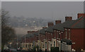
St James's road
A lot of the terraced streets in Blackburn are built on hillsides, some have stepped roofs such as this whilst others form one continuous slope Image The wasteland in the middle distance is the former site of the MD Foods Factory Image
Image: © Mr T
Taken: 28 Mar 2007
0.03 miles
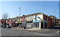
2

Terraced houses
Modern terraced houses, whoops, "Town Houses" or "Quasi-semi" as the estate agent like to call them, on Cedar Street. Built on the site of the demolished Cedar Street School.
Image: © Tony Mercer
Taken: 9 Feb 2009
0.04 miles
3

Terraced houses
Traditional terraced houses on Cedar Street. Although appearing the same, the houses in the distant terrace are bigger and the interior layouts vary greatly.
Image: © Tony Mercer
Taken: 2 Feb 2009
0.06 miles
5
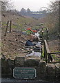
Little Harwood Brook
The plaque on the wall commemorates an 'Improvement scheme' but unfortunately doesn't mention a date, so I've no idea how long it took to look this good!
Image: © Mr T
Taken: 28 Mar 2007
0.10 miles
6
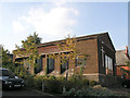
Hawthorne Street Methodist Blackburn
Located at the junction of Hawthorne Street with Cedar Street Blackburn still open when this image was taken.
Image: © Steve Houldsworth
Taken: Unknown
0.11 miles
7

Railway bridge over Laburnum Road
Gated to prevent access.
Image: © JThomas
Taken: 19 Apr 2019
0.12 miles
8
Mosque-Cedar Street
The former Hawthorn Street Methodist Chapel.
Image: © Tony Mercer
Taken: 2 Feb 2009
0.12 miles
9

Skew Bridge, Blackburn
The line from Blackburn to Clitheroe makes the A666 do an awkward wriggle.
Image: © Mike and Kirsty Grundy
Taken: 1 Aug 2005
0.12 miles
10
All doors and windows
Last used as a garage business
Image: © Alexander P Kapp
Taken: 15 Feb 2008
0.12 miles