IMAGES TAKEN NEAR TO
Roe Lee Park, BLACKBURN, BB1 9SA
Introduction
This page details the photographs taken nearby to Roe Lee Park, BB1 9SA by members of the Geograph project.
The Geograph project started in 2005 with the aim of publishing, organising and preserving representative images for every square kilometre of Great Britain, Ireland and the Isle of Man.

There are currently over 7.5m images from over14,400 individuals and you can help contribute to the project by visiting https://www.geograph.org.uk
Image Map
Images are licensed for reuse under creativecommons.org/licenses/by-sa/2.0
Notes
- Clicking on the map will re-center to the selected point.
- The higher the marker number, the further away the image location is from the centre of the postcode.
Image Listing (10 Images Found)
Images are licensed for reuse under creativecommons.org/licenses/by-sa/2.0
Image
Details
Distance
2
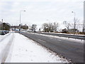
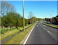
Road junction of Emerald Avenue and Brownhill Drive
Image: © Alexander P Kapp
Taken: 14 Jan 2010
0.14 miles
3
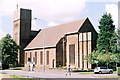
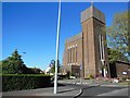
St Gabriel's Church, Brownhill, Blackburn
Verlarde 1932. Pevsner:"...one of the milestones in the development of architecture towards a 20thC style"
Image: © Mike and Kirsty Grundy
Taken: 6 Aug 2005
0.14 miles
8
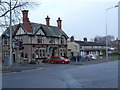
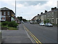
Brownhill Arms.
Brownhill Arms public house and row of cottages. Whalley New Road. Brownhill.
Image: © Tony Mercer
Taken: 1 Jan 2009
0.23 miles