IMAGES TAKEN NEAR TO
Brookview Close, BLACKBURN, BB1 9NT
Introduction
This page details the photographs taken nearby to Brookview Close, BB1 9NT by members of the Geograph project.
The Geograph project started in 2005 with the aim of publishing, organising and preserving representative images for every square kilometre of Great Britain, Ireland and the Isle of Man.

There are currently over 7.5m images from over14,400 individuals and you can help contribute to the project by visiting https://www.geograph.org.uk
Image Map
Images are licensed for reuse under creativecommons.org/licenses/by-sa/2.0
Notes
- Clicking on the map will re-center to the selected point.
- The higher the marker number, the further away the image location is from the centre of the postcode.
Image Listing (4 Images Found)
Images are licensed for reuse under creativecommons.org/licenses/by-sa/2.0
Image
Details
Distance
1
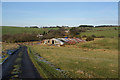
Shed below Parsonage Reservoir
The roof of this shed has been reinforced with the sides of articulated lorry trailers.
Image: © Bill Boaden
Taken: 21 Jan 2011
0.06 miles
3
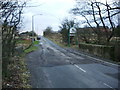
Entering Blackburn (Parsonage Road)
Image: © Alexander P Kapp
Taken: 23 Jan 2008
0.10 miles
4
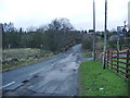
Parsonage Road, Blackburn
The change in the road surface marks the boundary between Blackburn and Lancashire CC. Lancashire CC must be slipping up because on most road leaving Blackburn, Lancashire CC have put up a sign saying "You are now entering Lancashire where everybody counts"? and they have missed this one.
Image: © Alexander P Kapp
Taken: 23 Jan 2008
0.11 miles