IMAGES TAKEN NEAR TO
Chapel Mews, James Street, BARNOLDSWICK, BB18 6XG
Introduction
This page details the photographs taken nearby to Chapel Mews, James Street, BB18 6XG by members of the Geograph project.
The Geograph project started in 2005 with the aim of publishing, organising and preserving representative images for every square kilometre of Great Britain, Ireland and the Isle of Man.

There are currently over 7.5m images from over14,400 individuals and you can help contribute to the project by visiting https://www.geograph.org.uk
Image Map (Loading...)


Getting Data...Please wait
Leaflet Map data © OpenStreetMap
Images are licensed for reuse under creativecommons.org/licenses/by-sa/2.0
Notes
- Clicking on the map will re-center to the selected point.
- The higher the marker number, the further away the image location is from the centre of the postcode.
Image Listing (52 Images Found)
Images are licensed for reuse under creativecommons.org/licenses/by-sa/2.0
Image
Details
Distance
4
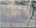
Ordnance Survey Cut Mark
This OS cut mark can be found on the wall west side of Colne Road. It marks a point 133.685m above mean sea level.
Image: © Adrian Dust
Taken: 19 Jun 2021
0.06 miles
7
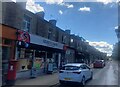
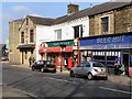
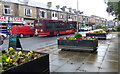
The Village Store on Colne Road, Earby
The Former Post Office Image] is now a cafe.
Showing position of Postbox N. BB18 348.
See Image] for postbox.
Image: © JThomas
Taken: 11 Aug 2018
0.07 miles
8
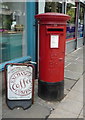
Elizabeth II postbox on Colne Road, Earby
Outside the former Post Office.
Postbox No. BB18 348.
See Image] for context.
Image: © JThomas
Taken: 11 Aug 2018
0.07 miles
10
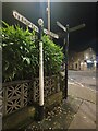
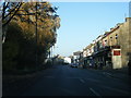
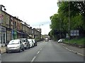
Direction Sign ? Signpost in Earby
Located on the east side of the A56 Skipton Road at the junction with Victoria Road in Earby parish. 3 arms and ball finial. A more recent photo of https://www.geograph.org.uk/photo/6681790 after restoration by Duncan Armstrong.
Milestone Society National ID: YW_SD9046
Image: © D Phillips
Taken: 19 Nov 2020
0.09 miles