IMAGES TAKEN NEAR TO
High Fold, BARNOLDSWICK, BB18 6TR
Introduction
This page details the photographs taken nearby to High Fold, BB18 6TR by members of the Geograph project.
The Geograph project started in 2005 with the aim of publishing, organising and preserving representative images for every square kilometre of Great Britain, Ireland and the Isle of Man.

There are currently over 7.5m images from over14,400 individuals and you can help contribute to the project by visiting https://www.geograph.org.uk
Image Map
Images are licensed for reuse under creativecommons.org/licenses/by-sa/2.0
Notes
- Clicking on the map will re-center to the selected point.
- The higher the marker number, the further away the image location is from the centre of the postcode.
Image Listing (43 Images Found)
Images are licensed for reuse under creativecommons.org/licenses/by-sa/2.0
Image
Details
Distance
1
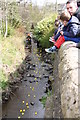
Duck Race
Kelbrook village duck race 2019
Image: © John Tomlinson
Taken: 13 Apr 2019
0.04 miles
3
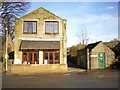
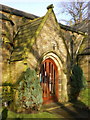
The Old Co-op
That's the name of the house and from the style of the building it was probably the Co-op shop.
Image: © Alexander P Kapp
Taken: 28 Jan 2009
0.05 miles
5
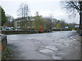
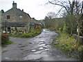
Road junction
The junction of Harden Road, Church Lane and Main Street at Low Bridge
Image: © Alexander P Kapp
Taken: 12 Nov 2009
0.07 miles
7
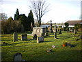
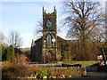
St Mary's Church, Kelbrook, Graveyard
Image: © Alexander P Kapp
Taken: 28 Jan 2009
0.08 miles
9
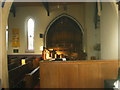
St Mary's Church, Kelbrook, Interior
Image: © Alexander P Kapp
Taken: 28 Jan 2009
0.08 miles
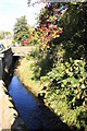
10

Kelbrook Pottery
A small pottery making stoneware for over 30yrs http://www.kelbrookpottery.com/10320/info.php?p=1&pno=0
Image: © Alexander P Kapp
Taken: 28 Jan 2009
0.08 miles