IMAGES TAKEN NEAR TO
Stoney Bank Road, BARNOLDSWICK, BB18 6RU
Introduction
This page details the photographs taken nearby to Stoney Bank Road, BB18 6RU by members of the Geograph project.
The Geograph project started in 2005 with the aim of publishing, organising and preserving representative images for every square kilometre of Great Britain, Ireland and the Isle of Man.

There are currently over 7.5m images from over14,400 individuals and you can help contribute to the project by visiting https://www.geograph.org.uk
Image Map
Images are licensed for reuse under creativecommons.org/licenses/by-sa/2.0
Notes
- Clicking on the map will re-center to the selected point.
- The higher the marker number, the further away the image location is from the centre of the postcode.
Image Listing (5 Images Found)
Images are licensed for reuse under creativecommons.org/licenses/by-sa/2.0
Image
Details
Distance
1
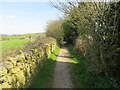
Mill Lane footpath near Earby
Looking north-westward. The path is used by the Pendle Way path.
Image: © Peter Wood
Taken: 20 Apr 2022
0.05 miles
2
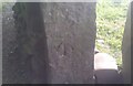
Ordnance Survey Cut Mark
This OS cut mark can be found on the gatepost SE side of Mill Lane. It marks a point 167.421m above mean sea level.
Image: © Adrian Dust
Taken: 19 Jun 2021
0.09 miles
3
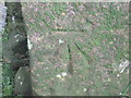
Ordnance Survey Cut Mark
This mark can be found on a gatepost in Mill Lane.
For more detail see : http://www.bench-marks.org.uk/bm43606
Image: © Peter Wood
Taken: 23 Jun 2012
0.09 miles
4
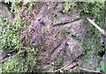
Ordnance Survey Cut Mark
This OS cut mark can be found on the back of the gatepost SE side of track. It marks a point 162.85m above mean sea level.
Image: © Adrian Dust
Taken: 20 Jun 2021
0.16 miles
5
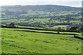
Barn above Earby
The barn is on Coolham Lane while Earby is down to the right.
Image: © Bill Boaden
Taken: 7 Oct 2011
0.24 miles