IMAGES TAKEN NEAR TO
Dale Street, BARNOLDSWICK, BB18 6QY
Introduction
This page details the photographs taken nearby to Dale Street, BB18 6QY by members of the Geograph project.
The Geograph project started in 2005 with the aim of publishing, organising and preserving representative images for every square kilometre of Great Britain, Ireland and the Isle of Man.

There are currently over 7.5m images from over14,400 individuals and you can help contribute to the project by visiting https://www.geograph.org.uk
Image Map (Loading...)


Getting Data...Please wait
Leaflet Map data © OpenStreetMap
Images are licensed for reuse under creativecommons.org/licenses/by-sa/2.0
Notes
- Clicking on the map will re-center to the selected point.
- The higher the marker number, the further away the image location is from the centre of the postcode.
Image Listing (42 Images Found)
Images are licensed for reuse under creativecommons.org/licenses/by-sa/2.0
Image
Details
Distance
1
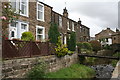
Earby: 71 to 83 Water Street
Earby Beck runs in front of these houses and small footbridges cross.
Image: © Dr Neil Clifton
Taken: 6 Sep 2017
0.07 miles
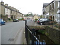
3
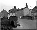
Bridge over Earby Beck
This shows also the lower end of Red Lion Street at its junction with Selborne Terrace.
Image: © Dr Neil Clifton
Taken: 22 Apr 1987
0.08 miles
4
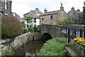
Earby: Bridge over Earby Beck
At the top of Water Street, the road crosses this bridge and changes its name to Red Lion Street.
Image: © Dr Neil Clifton
Taken: 6 Sep 2017
0.08 miles
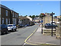
5
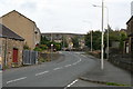
Water Street, Earby
One of the main streets in this small Lancashire town, also along the route of the Pendle Way Long Distance Footpath.
Image: © Chris Heaton
Taken: 7 Aug 2007
0.08 miles
6
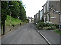
Red Lion Street, Earby
Running eastwards towards the Youth Hostel, carrying the Pendle Way Long Distance Footpath.
Image: © Chris Heaton
Taken: 7 Aug 2007
0.09 miles
8
Water Street in Earby
Looking north-westward.
Image: © Peter Wood
Taken: 17 Jul 2017
0.10 miles
9
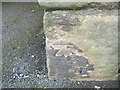
Ordnance Survey Cut Mark
This mark can be found on the wall of a house in Water Street.
For more detail see : http://www.bench-marks.org.uk/bm43627
Image: © Peter Wood
Taken: 23 Jun 2012
0.10 miles
10
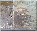
Ordnance Survey Cut Mark
This OS cut mark can be found on No22 Water Street. It marks a point 133.161m above mean sea level.
Image: © Adrian Dust
Taken: 19 Jun 2021
0.11 miles