IMAGES TAKEN NEAR TO
Skipton Road, BARNOLDSWICK, BB18 6QB
Introduction
This page details the photographs taken nearby to Skipton Road, BB18 6QB by members of the Geograph project.
The Geograph project started in 2005 with the aim of publishing, organising and preserving representative images for every square kilometre of Great Britain, Ireland and the Isle of Man.

There are currently over 7.5m images from over14,400 individuals and you can help contribute to the project by visiting https://www.geograph.org.uk
Image Map
Images are licensed for reuse under creativecommons.org/licenses/by-sa/2.0
Notes
- Clicking on the map will re-center to the selected point.
- The higher the marker number, the further away the image location is from the centre of the postcode.
Image Listing (48 Images Found)
Images are licensed for reuse under creativecommons.org/licenses/by-sa/2.0
Image
Details
Distance
1
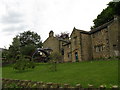
Yorkshire Dales Museum of Lead Mining, Earby
This small but interesting museum is housed in the premises of the former Earby Grammar School. Until 1974, Earby was administered by the West Riding County Council, but is now administered by the Borough of Pendle and Lancashire County Council. But most *Earbonians quite rightly regard themselves as Yorkshiremen or women.
(*I do not know if this is the correct term for a native of Earby)
Image: © Dr Neil Clifton
Taken: 26 May 2008
0.03 miles
2
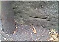
Ordnance Survey Cut Mark
This OS cut mark can be found on No68 Skipton Road. It marks a point 135.401m above mean sea level.
Image: © Adrian Dust
Taken: 19 Jun 2021
0.05 miles
3
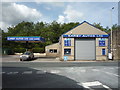
Earby Autos Ltd
Garage on Skipton Road (A56).
Image: © JThomas
Taken: 11 Aug 2018
0.08 miles
4
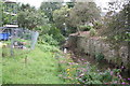
Earby: New Cut
This is the other stream to be seen in Earby, seen here looking upstream just above its confluence with Earby Beck
Image: © Dr Neil Clifton
Taken: 6 Sep 2017
0.08 miles
5
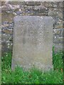
Old Guide Stone between Colne and Skipton, moved to School Lane, Earby
The original location of this guide-stoop is still being debated. Now in the grounds of the old Grammar School on School Lane, against the retaining wall on the left hand side of the driveway. The building, formerly the Mining Museum, is now owned by the Robert Windle Foundation.
Out of place - in public view.
Inscription reads: TOSKIPTOИ / И⅃OƆOT : TO / BLAC / KBVRИ
Milestone Society National ID: YW_XMUEB
Image: © Christine Minto
Taken: Unknown
0.08 miles
6
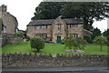
Earby the former Earby Grammar School
Until 2015 this was also the home of the Yorkshire Museum of Lead Mining.
Image: © Dr Neil Clifton
Taken: 6 Sep 2017
0.09 miles
7
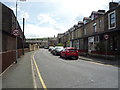
Albion Road, Earby
Looking east from Skipton Road (A56).
Image: © JThomas
Taken: 11 Aug 2018
0.09 miles
8
Earby: Junction of School Lane and Old Lane
The road running across the picture is School Lane; Old Lane goes off to the right. The building, left centre, is the former Earby Grammar School
Image: © Dr Neil Clifton
Taken: 6 Sep 2017
0.09 miles
9
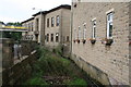
Earby: Earby Beck
Earby Beck flows through the middle of the town, for much of its length alongside Water Street. Quite a bit of the beck has been covered over, and in other places there are small footbridges. Here the beck is seen looking downstream as it passes some industrial premises.
Image: © Dr Neil Clifton
Taken: 6 Sep 2017
0.09 miles