IMAGES TAKEN NEAR TO
Coolham Lane, BARNOLDSWICK, BB18 6LE
Introduction
This page details the photographs taken nearby to Coolham Lane, BB18 6LE by members of the Geograph project.
The Geograph project started in 2005 with the aim of publishing, organising and preserving representative images for every square kilometre of Great Britain, Ireland and the Isle of Man.

There are currently over 7.5m images from over14,400 individuals and you can help contribute to the project by visiting https://www.geograph.org.uk
Image Map
Images are licensed for reuse under creativecommons.org/licenses/by-sa/2.0
Notes
- Clicking on the map will re-center to the selected point.
- The higher the marker number, the further away the image location is from the centre of the postcode.
Image Listing (3 Images Found)
Images are licensed for reuse under creativecommons.org/licenses/by-sa/2.0
Image
Details
Distance
1
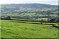
Barn above Earby
The barn is on Coolham Lane while Earby is down to the right.
Image: © Bill Boaden
Taken: 7 Oct 2011
0.01 miles
2
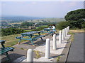
A picnic on Bleara Moor, Yorkshire
The minor road from the A56 at Earby to Lothersdale climbs steeply out of Earby to cross Bleara Moor, and at the crest of the hill the local authority have thoughtfully provided a pleasant picnic site with sturdy tables and car parking. The site has outstanding views over the surrounding countryside and is very popular.
Image: © Dr Neil Clifton
Taken: 20 Jul 2006
0.13 miles
3
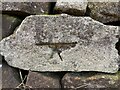
Unknown cutmark
Unknown cutmark on Standridge Clough Lane
Image: © Loz
Taken: 18 Jan 2022
0.22 miles